Almada geodata
Almada (District of Setúbal) is a seat of a second-order administrative division; located in Portugal in Europe/Lisbon (GMT+1) time zone. With population of 34,008 people, there are 40 cities with bigger population in this country. Compared to other cities in Portugal, 75.7% of cities are located further ↑North; 81.1% of cities are located further →East and 66.6% of cities have higher elevation than Almada. Note1


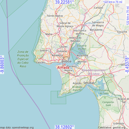
Almada GPS coordinates[2]
38° 40' 44.472" North, 9° 9' 24.84" West
| Map corner | latitude | longitude |
|---|---|---|
| Upper-left | 39.22581°, | -9.86003° |
| Center: | 38.67902°, | -9.1569° |
| Lower-right: | 38.12802°, | -8.45378° |
| Map W x H: | 122.1×122.1 km | = 75.9×75.9mi |
| max Lat: | 42.11337° ⇑75.7% North |
| Almada: | 38.67902° |
| min Lat: | ⇓24.3% South 32.6448° |
| min Long | Almada | max Long |
| -31.17847° | -9.1569° | -6.27308° |
| W 18.9%⇐ | ⇒81.1% E |
Elevation
Elevation of Almada is 58 m = 190 ft, and this is 119 m = 390 ft below average elevation for this country.
| Max E: |
1008 m = 3307 ft | 66.6% |
| Avg. | 177 m = 581 ft | |
| Almada | 58 m = 190 ft | |
Min E: |
-128 m = -420 ft | 33.4% |
See also: Portugal elevation on elevation.city.
Geographical zone
Almada is located in North temperate zone (between Tropic of Cancer and the Arctic Circle). Distance of this Northern Tropic circle is 1694.8 km =1053.1 mi to South.| Distance of | km | miles | from Almada |
|---|---|---|---|
| North Pole | 5706.4 | 3545.8 | to North |
| Arctic Circle | 3100.5 | 1926.6 | to North |
| Tropic Cancer | 1694.8 | 1053.1 | to South |
| Equator | 4300.7 | 2672.3 | to South |


Nearby cities:
15 places around Almada: (largest is in red/bold)
• Algés
6.8 km =4.2 mi,  292°
292°
• Amora
6.6 km =4.1 mi,  146°
146°
• Barreiro
7.5 km =4.7 mi,  103°
103°
• Cacilhas
1 km =0.6 mi,  38°
38°
• Caparica
4.2 km =2.6 mi,  243°
243°
• Charneca de Caparica
7.3 km =4.5 mi,  206°
206°
• Corroios
4.4 km =2.7 mi,  173°
173°
• Laranjeira
2.6 km =1.6 mi, 173°
• Lisbon
4.7 km =2.9 mi,  26°
26°
• Piedade
1 km =0.6 mi,  188°
188°
• Pragal
1.2 km =0.7 mi,  246°
246°
• Santos-o-Velho
3.1 km =1.9 mi,  1°
1°
• Seixal
6.5 km =4 mi,  131°
131°
• Sobreda
4.3 km =2.7 mi,  221°
221°
• Trafaria
6.6 km =4.1 mi,  263°
263°
Sources, notices
• [Note1] Compared only with cities in Portugal existing in our database
• [Src1] Map data: © OpenStreetMap contributors (CC-BY-SA)
• [Src2] Other city data from geonames.org with taken over terms of usage.
• [Src3] Geographical zone / Annual Mean Temperature by Robert A. Rohde @ Wikipedia
