Vila Nova de Foz Côa geodata
Vila Nova de Foz Côa (Guarda) is a seat of a second-order administrative division; located in Portugal in Europe/Lisbon (GMT+1) time zone. With population of 7,312 people, there are 307 cities with bigger population in this country. Compared to other cities in Portugal, 73.3% of cities are located further ↓South; 98% of cities are located further ←West and 86.2% of cities have lower elevation than Vila Nova de Foz Côa. Note1
Current local time in Vila Nova de Foz Côa:
11:56 PM, WednesdayDifference from your time zone: hours


Vila Nova de Foz Côa GPS coordinates[2]
41° 4' 54.984" North, 7° 8' 29.256" West
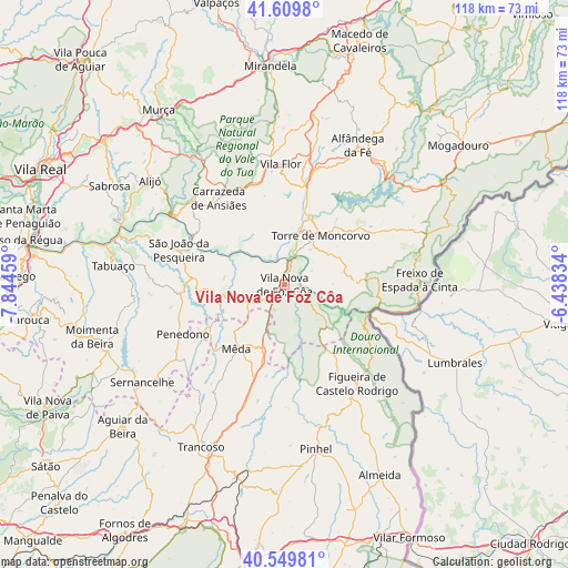
| Map corner | latitude | longitude |
|---|---|---|
| Upper-left | 41.6098°, | -7.84459° |
| Center: | 41.08194°, | -7.14146° |
| Lower-right: | 40.54981°, | -6.43834° |
| Map W x H: | 117.9×117.9 km | = 73.3×73.3mi |
| max Lat: | 42.11337° ⇑26.7% North |
| Vila Nova de Foz Côa: | 41.08194° |
| min Lat: | ⇓73.3% South 32.6448° |
| min Long | Vila Nova de Fo | max Long |
| -31.17847° | -7.14146° | -6.27308° |
| W 98%⇐ | ⇒2% E |
Elevation
Elevation of Vila Nova de Foz Côa is 385 m = 1263 ft, and this is 208 m = 682 ft above average elevation for this country.
| Max E: |
1008 m = 3307 ft | 13.8% |
| Vila Nova de Foz Côa | 385 m 1263 ft | |
| Avg. | 177 m = 581 ft | |
Min E: |
-128 m = -420 ft | 86.2% |
See also: Portugal elevation on elevation.city.
Geographical zone
Vila Nova de Foz Côa is located in North temperate zone (between Tropic of Cancer and the Arctic Circle). Distance of this Northern Tropic circle is 1962 km =1219.1 mi to South.| Distance of | km | miles | from Vila Nova de Foz Côa |
|---|---|---|---|
| North Pole | 5439.2 | 3379.8 | to North |
| Arctic Circle | 2833.3 | 1760.5 | to North |
| Tropic Cancer | 1962 | 1219.1 | to South |
| Equator | 4567.9 | 2838.4 | to South |


Nearby cities:
15 places around Vila Nova de Foz Côa: (largest is in red/bold)
• Alfândega da Fé
32.7 km =20.3 mi,  27°
27°
• Belver
21.5 km =13.4 mi,  328°
328°
• Carrazeda de Anciães
22.6 km =14 mi,  322°
322°
• Custoias
15.3 km =9.5 mi,  279°
279°
• Ervedosa do Douro
29.3 km =18.2 mi,  288°
288°
• Figueira de Castelo Rodrigo
25.8 km =16 mi,  144°
144°
• Freixo de Espada à Cinta
28.1 km =17.5 mi,  88°
88°
• Freixo de Numão
6.9 km =4.3 mi,  256°
256°
• Mêda
16.3 km =10.1 mi,  218°
218°
• Penedono
23.6 km =14.7 mi,  243°
243°
• Pinhel
34.8 km =21.6 mi,  169°
169°
• São João da Pesqueira
23.3 km =14.5 mi, 288°
• Torre de Moncorvo
12.7 km =7.9 mi,  35°
35°
• Trevões
24.6 km =15.3 mi,  269°
269°
• Vila Flor
25.3 km =15.7 mi,  357°
357°
Sources, notices
• [Note1] Compared only with cities in Portugal existing in our database
• [Src1] Map data: © OpenStreetMap contributors (CC-BY-SA)
• [Src2] Other city data from geonames.org with taken over terms of usage.
• [Src3] Geographical zone / Annual Mean Temperature by Robert A. Rohde @ Wikipedia
