Mêda geodata
Mêda (Guarda) is a seat of a second-order administrative division; located in Portugal in Europe/Lisbon (GMT+1) time zone. With population of 2,004 people, there are 644 cities with bigger population in this country. Compared to other cities in Portugal, 69.5% of cities are located further ↓South; 97.1% of cities are located further ←West and 97.9% of cities have lower elevation than Mêda. Note1


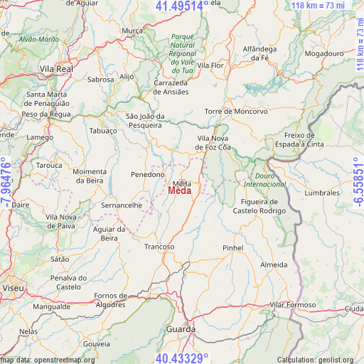
Mêda GPS coordinates[2]
40° 57' 58.86" North, 7° 15' 41.868" West
| Map corner | latitude | longitude |
|---|---|---|
| Upper-left | 41.49514°, | -7.96476° |
| Center: | 40.96635°, | -7.26163° |
| Lower-right: | 40.43329°, | -6.55851° |
| Map W x H: | 118.1×118.1 km | = 73.4×73.4mi |
| max Lat: | 42.11337° ⇑30.5% North |
| Mêda: | 40.96635° |
| min Lat: | ⇓69.5% South 32.6448° |
| min Long | Mêda | max Long |
| -31.17847° | -7.26163° | -6.27308° |
| W 97.1%⇐ | ⇒2.9% E |
Elevation
Elevation of Mêda is 713 m = 2339 ft, and this is 536 m = 1759 ft above average elevation for this country.
| Max E: |
1008 m = 3307 ft | 2.1% |
| Mêda | 713 m 2339 ft | |
| Avg. | 177 m = 581 ft | |
Min E: |
-128 m = -420 ft | 97.9% |
See also: Portugal elevation on elevation.city.
Geographical zone
Mêda is located in North temperate zone (between Tropic of Cancer and the Arctic Circle). Distance of this Northern Tropic circle is 1949.1 km =1211.1 mi to South.| Distance of | km | miles | from Mêda |
|---|---|---|---|
| North Pole | 5452 | 3387.7 | to North |
| Arctic Circle | 2846.1 | 1768.5 | to North |
| Tropic Cancer | 1949.1 | 1211.1 | to South |
| Equator | 4555 | 2830.3 | to South |


Nearby cities:
15 places around Mêda: (largest is in red/bold)
• Aguiar da Beira
29 km =18 mi,  235°
235°
• Custoias
16.2 km =10.1 mi,  342°
342°
• Ervedosa do Douro
28.4 km =17.6 mi,  321°
321°
• Figueira de Castelo Rodrigo
26.4 km =16.4 mi,  108°
108°
• Freixo de Numão
11.7 km =7.3 mi,  16°
16°
• Moimenta da Beira
30 km =18.6 mi,  273°
273°
• Penedono
11.4 km =7.1 mi,  282°
282°
• Pinhel
26.9 km =16.7 mi,  142°
142°
• Rua
26.4 km =16.4 mi, 265°
• Sernancelhe
20.9 km =13 mi,  248°
248°
• São João da Pesqueira
23.5 km =14.6 mi,  329°
329°
• Torre de Moncorvo
29 km =18 mi,  36°
36°
• Trancoso
21.7 km =13.5 mi,  200°
200°
• Trevões
19.4 km =12.1 mi,  311°
311°
• Vila Nova de Foz Côa
16.3 km =10.1 mi, 38°
Sources, notices
• [Note1] Compared only with cities in Portugal existing in our database
• [Src1] Map data: © OpenStreetMap contributors (CC-BY-SA)
• [Src2] Other city data from geonames.org with taken over terms of usage.
• [Src3] Geographical zone / Annual Mean Temperature by Robert A. Rohde @ Wikipedia
