Pinhel geodata
Pinhel (Guarda) is a seat of a second-order administrative division; located in Portugal in Europe/Lisbon (GMT+1) time zone. In our database, there are 824 cities with bigger population. Compared to other cities in Portugal, 66% of cities are located further ↓South; 98.3% of cities are located further ←West and 96% of cities have lower elevation than Pinhel. Note1


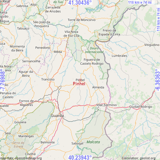
Pinhel GPS coordinates[2]
40° 46' 26.508" North, 7° 4' 0.3" West
| Map corner | latitude | longitude |
|---|---|---|
| Upper-left | 41.30436°, | -7.76988° |
| Center: | 40.77403°, | -7.06675° |
| Lower-right: | 40.23943°, | -6.36363° |
| Map W x H: | 118.4×118.4 km | = 73.6×73.6mi |
| max Lat: | 42.11337° ⇑34% North |
| Pinhel: | 40.77403° |
| min Lat: | ⇓66% South 32.6448° |
| min Long | Pinhel | max Long |
| -31.17847° | -7.06675° | -6.27308° |
| W 98.3%⇐ | ⇒1.7% E |
Elevation
Elevation of Pinhel is 645 m = 2116 ft, and this is 468 m = 1535 ft above average elevation for this country.
| Max E: |
1008 m = 3307 ft | 4% |
| Pinhel | 645 m 2116 ft | |
| Avg. | 177 m = 581 ft | |
Min E: |
-128 m = -420 ft | 96% |
See also: Portugal elevation on elevation.city.
Geographical zone
Pinhel is located in North temperate zone (between Tropic of Cancer and the Arctic Circle). Distance of this Northern Tropic circle is 1927.7 km =1197.8 mi to South.| Distance of | km | miles | from Pinhel |
|---|---|---|---|
| North Pole | 5473.4 | 3401 | to North |
| Arctic Circle | 2867.5 | 1781.8 | to North |
| Tropic Cancer | 1927.7 | 1197.8 | to South |
| Equator | 4533.6 | 2817 | to South |


Nearby cities:
15 places around Pinhel: (largest is in red/bold)
• Aguiar da Beira
40.5 km =25.2 mi,  276°
276°
• Celorico da Beira
31.2 km =19.4 mi,  240°
240°
• Custoias
42.6 km =26.5 mi,  329°
329°
• Figueira de Castelo Rodrigo
15.8 km =9.8 mi,  33°
33°
• Fornos de Algodres
43.1 km =26.8 mi,  247°
247°
• Freixo de Espada à Cinta
41.4 km =25.7 mi, 31°
• Freixo de Numão
35.1 km =21.8 mi,  338°
338°
• Guarda
31.2 km =19.4 mi,  212°
212°
• Mêda
26.9 km =16.7 mi,  322°
322°
• Penedono
36.4 km =22.6 mi,  310°
310°
• Sequeira
27.9 km =17.3 mi, 208°
• Sernancelhe
38.5 km =23.9 mi,  291°
291°
• Torre de Moncorvo
44.5 km =27.7 mi,  1°
1°
• Trancoso
23.9 km =14.9 mi,  272°
272°
• Vila Nova de Foz Côa
34.8 km =21.6 mi,  349°
349°
Sources, notices
• [Note1] Compared only with cities in Portugal existing in our database
• [Src1] Map data: © OpenStreetMap contributors (CC-BY-SA)
• [Src2] Other city data from geonames.org with taken over terms of usage.
• [Src3] Geographical zone / Annual Mean Temperature by Robert A. Rohde @ Wikipedia
