Tondela geodata
Tondela (Viseu) is a seat of a second-order administrative division; located in Portugal in Europe/Lisbon (GMT+1) time zone. With population of 8,800 people, there are 253 cities with bigger population in this country. Compared to other cities in Portugal, 61.4% of cities are located further ↓South; 77.3% of cities are located further ←West and 81.4% of cities have lower elevation than Tondela. Note1


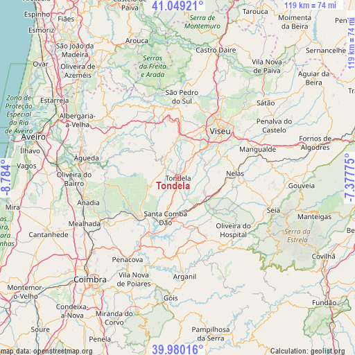
Tondela GPS coordinates[2]
40° 31' 0.552" North, 8° 4' 51.132" West
| Map corner | latitude | longitude |
|---|---|---|
| Upper-left | 41.04921°, | -8.784° |
| Center: | 40.51682°, | -8.08087° |
| Lower-right: | 39.98016°, | -7.37775° |
| Map W x H: | 118.9×118.9 km | = 73.9×73.9mi |
| max Lat: | 42.11337° ⇑38.6% North |
| Tondela: | 40.51682° |
| min Lat: | ⇓61.4% South 32.6448° |
| min Long | Tondela | max Long |
| -31.17847° | -8.08087° | -6.27308° |
| W 77.3%⇐ | ⇒22.7% E |
Elevation
Elevation of Tondela is 305 m = 1001 ft, and this is 128 m = 420 ft above average elevation for this country.
| Max E: |
1008 m = 3307 ft | 18.6% |
| Tondela | 305 m 1001 ft | |
| Avg. | 177 m = 581 ft | |
Min E: |
-128 m = -420 ft | 81.4% |
See also: Portugal elevation on elevation.city.
Geographical zone
Tondela is located in North temperate zone (between Tropic of Cancer and the Arctic Circle). Distance of this Northern Tropic circle is 1899.1 km =1180 mi to South.| Distance of | km | miles | from Tondela |
|---|---|---|---|
| North Pole | 5502 | 3418.8 | to North |
| Arctic Circle | 2896.1 | 1799.6 | to North |
| Tropic Cancer | 1899.1 | 1180 | to South |
| Equator | 4505 | 2799.3 | to South |


Nearby cities:
15 places around Tondela: (largest is in red/bold)
• Abraveses
22.7 km =14.1 mi,  36°
36°
• Cabanas de Viriato
10 km =6.2 mi,  116°
116°
• Campo de Besteiros
6.3 km =3.9 mi,  314°
314°
• Canas de Senhorim
15.5 km =9.6 mi,  96°
96°
• Carregal do Sal
11.5 km =7.1 mi,  143°
143°
• Lapa do Lobo
14.5 km =9 mi,  108°
108°
• Mortágua
18.5 km =11.5 mi,  223°
223°
• Nelas
19.5 km =12.1 mi,  84°
84°
• Parada de Gonta
10.5 km =6.5 mi, 44°
• Santa Comba Dão
13.8 km =8.6 mi,  198°
198°
• São João de Areias
14.5 km =9 mi,  175°
175°
• Treixedo
9.4 km =5.8 mi,  186°
186°
• Tábua
17.8 km =11.1 mi,  165°
165°
• Viseu
21.6 km =13.4 mi, 42°
• Vouzela
23.2 km =14.4 mi,  353°
353°
Sources, notices
• [Note1] Compared only with cities in Portugal existing in our database
• [Src1] Map data: © OpenStreetMap contributors (CC-BY-SA)
• [Src2] Other city data from geonames.org with taken over terms of usage.
• [Src3] Geographical zone / Annual Mean Temperature by Robert A. Rohde @ Wikipedia
