Mortágua geodata
Mortágua (Viseu) is a seat of a second-order administrative division; located in Portugal in Europe/Lisbon (GMT+1) time zone. In our database, there are 824 cities with bigger population. Compared to other cities in Portugal, 59.6% of cities are located further ↓South; 71.9% of cities are located further ←West and 52.8% of cities have higher elevation than Mortágua. Note1


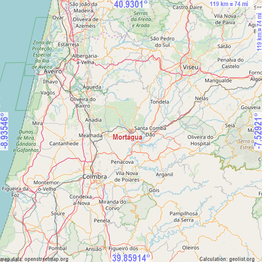
Mortágua GPS coordinates[2]
40° 23' 48.3" North, 8° 13' 56.424" West
| Map corner | latitude | longitude |
|---|---|---|
| Upper-left | 40.9301°, | -8.93546° |
| Center: | 40.39675°, | -8.23234° |
| Lower-right: | 39.85914°, | -7.52921° |
| Map W x H: | 119.1×119.1 km | = 74×74mi |
| max Lat: | 42.11337° ⇑40.4% North |
| Mortágua: | 40.39675° |
| min Lat: | ⇓59.6% South 32.6448° |
| min Long | Mortágua | max Long |
| -31.17847° | -8.23234° | -6.27308° |
| W 71.9%⇐ | ⇒28.1% E |
Elevation
Elevation of Mortágua is 100 m = 328 ft, and this is 77 m = 253 ft below average elevation for this country.
| Max E: |
1008 m = 3307 ft | 52.8% |
| Avg. | 177 m = 581 ft | |
| Mortágua | 100 m = 328 ft | |
Min E: |
-128 m = -420 ft | 47.2% |
See also: Portugal elevation on elevation.city.
Geographical zone
Mortágua is located in North temperate zone (between Tropic of Cancer and the Arctic Circle). Distance of this Northern Tropic circle is 1885.8 km =1171.8 mi to South.| Distance of | km | miles | from Mortágua |
|---|---|---|---|
| North Pole | 5515.4 | 3427.1 | to North |
| Arctic Circle | 2909.5 | 1807.9 | to North |
| Tropic Cancer | 1885.8 | 1171.8 | to South |
| Equator | 4491.7 | 2791 | to South |


Nearby cities:
15 places around Mortágua: (largest is in red/bold)
• Anadia
17.6 km =10.9 mi,  285°
285°
• Friumes
13.9 km =8.6 mi,  174°
174°
• Lorvão
16.9 km =10.5 mi,  205°
205°
• Luso
12.5 km =7.8 mi,  263°
263°
• Mealhada
18.5 km =11.5 mi, 263°
• Oliveira do Mondego
8.2 km =5.1 mi, 174°
• Pampilhosa do Botão
17.9 km =11.1 mi,  247°
247°
• Penacova
14.8 km =9.2 mi,  196°
196°
• Santa Comba Dão
8.5 km =5.3 mi,  88°
88°
• São João de Areias
14 km =8.7 mi, 94°
• São Pedro de Alva
12.1 km =7.5 mi,  152°
152°
• Tondela
18.5 km =11.5 mi,  43°
43°
• Travanca
9 km =5.6 mi, 154°
• Treixedo
12.3 km =7.6 mi,  71°
71°
• Tábua
17.6 km =10.9 mi,  102°
102°
Sources, notices
• [Note1] Compared only with cities in Portugal existing in our database
• [Src1] Map data: © OpenStreetMap contributors (CC-BY-SA)
• [Src2] Other city data from geonames.org with taken over terms of usage.
• [Src3] Geographical zone / Annual Mean Temperature by Robert A. Rohde @ Wikipedia
