Abraveses geodata
Abraveses (Viseu) is a populated place; located in Portugal in Europe/Lisbon (GMT+0) time zone. With population of 9,319 people, there are 236 cities with bigger population in this country. Compared to other cities in Portugal, 64.5% of cities are located further ↓South; 81.6% of cities are located further ←West and 91.7% of cities have lower elevation than Abraveses. Note1


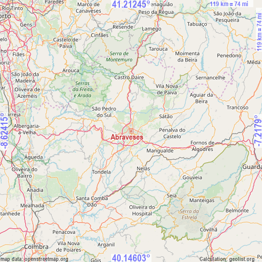
Abraveses GPS coordinates[2]
40° 40' 52.932" North, 7° 55' 15.672" West
| Map corner | latitude | longitude |
|---|---|---|
| Upper-left | 41.21245°, | -8.62415° |
| Center: | 40.68137°, | -7.92102° |
| Lower-right: | 40.14603°, | -7.2179° |
| Map W x H: | 118.6×118.6 km | = 73.7×73.7mi |
| max Lat: | 42.11337° ⇑35.5% North |
| Abraveses: | 40.68137° |
| min Lat: | ⇓64.5% South 32.6448° |
| min Long | Abraveses | max Long |
| -31.17847° | -7.92102° | -6.27308° |
| W 81.6%⇐ | ⇒18.4% E |
Elevation
Elevation of Abraveses is 512 m = 1680 ft, and this is 335 m = 1099 ft above average elevation for this country.
| Max E: |
1008 m = 3307 ft | 8.3% |
| Abraveses | 512 m 1680 ft | |
| Avg. | 177 m = 581 ft | |
Min E: |
-128 m = -420 ft | 91.7% |
See also: Portugal elevation on elevation.city.
Geographical zone
Abraveses is located in North temperate zone (between Tropic of Cancer and the Arctic Circle). Distance of this Northern Tropic circle is 1917.4 km =1191.4 mi to South.| Distance of | km | miles | from Abraveses |
|---|---|---|---|
| North Pole | 5483.7 | 3407.4 | to North |
| Arctic Circle | 2877.8 | 1788.2 | to North |
| Tropic Cancer | 1917.4 | 1191.4 | to South |
| Equator | 4523.3 | 2810.6 | to South |


Nearby cities:
15 places around Abraveses: (largest is in red/bold)
• Campo
3.3 km =2.1 mi,  9°
9°
• Campo de Besteiros
22.7 km =14.1 mi,  232°
232°
• Canas de Senhorim
20.2 km =12.6 mi,  174°
174°
• Lapa do Lobo
22.8 km =14.2 mi,  179°
179°
• Mangualde
16 km =9.9 mi,  122°
122°
• Mesquitela
18.2 km =11.3 mi,  125°
125°
• Nelas
17.6 km =10.9 mi,  160°
160°
• Oliveira de Frades
22.2 km =13.8 mi,  285°
285°
• Parada de Gonta
12.5 km =7.8 mi,  209°
209°
• Rio de Loba
4 km =2.5 mi, 115°
• Sátão
17.2 km =10.7 mi,  67°
67°
• São Pedro do Sul
15.2 km =9.4 mi,  302°
302°
• Tondela
22.7 km =14.1 mi,  216°
216°
• Viseu
2.5 km =1.6 mi, 157°
• Vouzela
16.8 km =10.4 mi, 286°
Sources, notices
• [Note1] Compared only with cities in Portugal existing in our database
• [Src1] Map data: © OpenStreetMap contributors (CC-BY-SA)
• [Src2] Other city data from geonames.org with taken over terms of usage.
• [Src3] Geographical zone / Annual Mean Temperature by Robert A. Rohde @ Wikipedia
