Tábua geodata
Tábua (Coimbra) is a seat of a second-order administrative division; located in Portugal in Europe/Lisbon (GMT+1) time zone. With population of 12,071 people, there are 168 cities with bigger population in this country. Compared to other cities in Portugal, 59.2% of cities are located further ↓South; 78.3% of cities are located further ←West and 75.5% of cities have lower elevation than Tábua. Note1


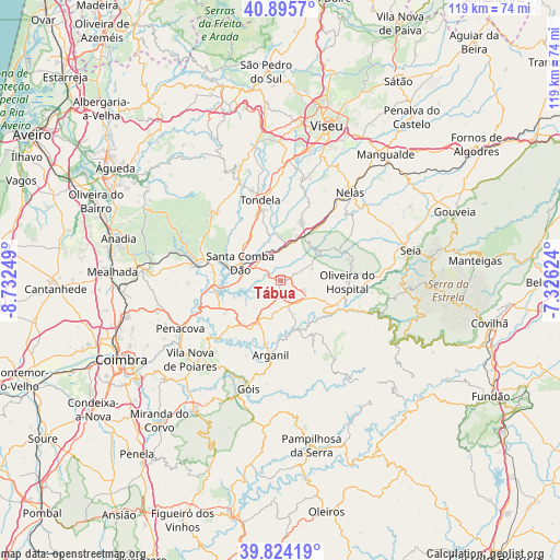
Tábua GPS coordinates[2]
40° 21' 43.452" North, 8° 1' 45.696" West
| Map corner | latitude | longitude |
|---|---|---|
| Upper-left | 40.8957°, | -8.73249° |
| Center: | 40.36207°, | -8.02936° |
| Lower-right: | 39.82419°, | -7.32624° |
| Map W x H: | 119.1×119.1 km | = 74×74mi |
| max Lat: | 42.11337° ⇑40.8% North |
| Tábua: | 40.36207° |
| min Lat: | ⇓59.2% South 32.6448° |
| min Long | Tábua | max Long |
| -31.17847° | -8.02936° | -6.27308° |
| W 78.3%⇐ | ⇒21.7% E |
Elevation
Elevation of Tábua is 239 m = 784 ft, and this is 62 m = 203 ft above average elevation for this country.
| Max E: |
1008 m = 3307 ft | 24.5% |
| Tábua | 239 m 784 ft | |
| Avg. | 177 m = 581 ft | |
Min E: |
-128 m = -420 ft | 75.5% |
See also: Portugal elevation on elevation.city.
Geographical zone
Tábua is located in North temperate zone (between Tropic of Cancer and the Arctic Circle). Distance of this Northern Tropic circle is 1881.9 km =1169.4 mi to South.| Distance of | km | miles | from Tábua |
|---|---|---|---|
| North Pole | 5519.2 | 3429.5 | to North |
| Arctic Circle | 2913.3 | 1810.2 | to North |
| Tropic Cancer | 1881.9 | 1169.4 | to South |
| Equator | 4487.8 | 2788.6 | to South |


Nearby cities:
15 places around Tábua: (largest is in red/bold)
• Arganil
16.1 km =10 mi,  187°
187°
• Avô
13.2 km =8.2 mi,  125°
125°
• Cabanas de Viriato
13.6 km =8.5 mi,  20°
20°
• Carregal do Sal
8.3 km =5.2 mi, 17°
• Lapa do Lobo
15.8 km =9.8 mi,  36°
36°
• Mortágua
17.6 km =10.9 mi,  282°
282°
• Oliveira do Hospital
14.3 km =8.9 mi,  90°
90°
• Oliveira do Mondego
17 km =10.6 mi,  255°
255°
• Santa Comba Dão
9.6 km =6 mi,  295°
295°
• Santa Ovaia
13.3 km =8.3 mi,  113°
113°
• São João de Areias
4.3 km =2.7 mi,  310°
310°
• São Pedro de Alva
13.5 km =8.4 mi,  239°
239°
• Tondela
17.8 km =11.1 mi,  345°
345°
• Travanca
14 km =8.7 mi,  252°
252°
• Treixedo
9.6 km =6 mi,  324°
324°
Sources, notices
• [Note1] Compared only with cities in Portugal existing in our database
• [Src1] Map data: © OpenStreetMap contributors (CC-BY-SA)
• [Src2] Other city data from geonames.org with taken over terms of usage.
• [Src3] Geographical zone / Annual Mean Temperature by Robert A. Rohde @ Wikipedia
