Sernancelhe geodata
Sernancelhe (Viseu) is a seat of a second-order administrative division; located in Portugal in Europe/Lisbon (GMT+1) time zone. With population of 5,671 people, there are 382 cities with bigger population in this country. Compared to other cities in Portugal, 68% of cities are located further ↓South; 92.5% of cities are located further ←West and 98.4% of cities have lower elevation than Sernancelhe. Note1


Sernancelhe GPS coordinates[2]
40° 53' 55.356" North, 7° 29' 36.312" West
| Map corner | latitude | longitude |
|---|---|---|
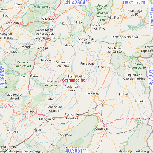
| Upper-left | 41.42804°, | -8.19655° |
| Center: | 40.89871°, | -7.49342° |
| Lower-right: | 40.36511°, | -6.7903° |
| Map W x H: | 118.2×118.2 km | = 73.4×73.4mi |
| max Lat: | 42.11337° ⇑32% North |
| Sernancelhe: | 40.89871° |
| min Lat: | ⇓68% South 32.6448° |
| min Long | Sernancelhe | max Long |
| -31.17847° | -7.49342° | -6.27308° |
| W 92.5%⇐ | ⇒7.5% E |
Elevation
Elevation of Sernancelhe is 753 m = 2470 ft, and this is 576 m = 1890 ft above average elevation for this country.
| Max E: |
1008 m = 3307 ft | 1.6% |
| Sernancelhe | 753 m 2470 ft | |
| Avg. | 177 m = 581 ft | |
Min E: |
-128 m = -420 ft | 98.4% |
See also: Portugal elevation on elevation.city.
Geographical zone
Sernancelhe is located in North temperate zone (between Tropic of Cancer and the Arctic Circle). Distance of this Northern Tropic circle is 1941.6 km =1206.5 mi to South.| Distance of | km | miles | from Sernancelhe |
|---|---|---|---|
| North Pole | 5459.6 | 3392.4 | to North |
| Arctic Circle | 2853.7 | 1773.2 | to North |
| Tropic Cancer | 1941.6 | 1206.5 | to South |
| Equator | 4547.5 | 2825.7 | to South |


Nearby cities:
15 places around Sernancelhe: (largest is in red/bold)
• Aguiar da Beira
10 km =6.2 mi,  205°
205°
• Armamar
28.6 km =17.8 mi,  324°
324°
• Custoias
27.1 km =16.8 mi,  32°
32°
• Moimenta da Beira
14.1 km =8.8 mi,  312°
312°
• Mondim da Beira
25.1 km =15.6 mi,  302°
302°
• Mêda
20.9 km =13 mi,  68°
68°
• Penedono
13 km =8.1 mi,  39°
39°
• Rua
8.8 km =5.5 mi, 308°
• Sátão
26.7 km =16.6 mi,  229°
229°
• São João da Pesqueira
28.7 km =17.8 mi,  14°
14°
• Tabuaço
25 km =15.5 mi,  345°
345°
• Tarouca
27.1 km =16.8 mi, 299°
• Trancoso
17.6 km =10.9 mi,  136°
136°
• Trevões
20.9 km =13 mi, 13°
• Vila Nova de Paiva
20.4 km =12.7 mi,  255°
255°
Sources, notices
• [Note1] Compared only with cities in Portugal existing in our database
• [Src1] Map data: © OpenStreetMap contributors (CC-BY-SA)
• [Src2] Other city data from geonames.org with taken over terms of usage.
• [Src3] Geographical zone / Annual Mean Temperature by Robert A. Rohde @ Wikipedia
