Vila Nova de Paiva geodata
Vila Nova de Paiva (Viseu) is a seat of a second-order administrative division; located in Portugal in Europe/Lisbon (GMT+1) time zone. With population of 5,176 people, there are 410 cities with bigger population in this country. Compared to other cities in Portugal, 66.9% of cities are located further ↓South; 87.3% of cities are located further ←West and 99.2% of cities have lower elevation than Vila Nova de Paiva. Note1


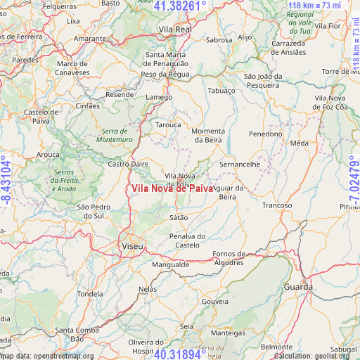
Vila Nova de Paiva GPS coordinates[2]
40° 51' 10.476" North, 7° 43' 40.476" West
| Map corner | latitude | longitude |
|---|---|---|
| Upper-left | 41.38261°, | -8.43104° |
| Center: | 40.85291°, | -7.72791° |
| Lower-right: | 40.31894°, | -7.02479° |
| Map W x H: | 118.3×118.3 km | = 73.5×73.5mi |
| max Lat: | 42.11337° ⇑33.1% North |
| Vila Nova de Paiva: | 40.85291° |
| min Lat: | ⇓66.9% South 32.6448° |
| min Long | Vila Nova de Pa | max Long |
| -31.17847° | -7.72791° | -6.27308° |
| W 87.3%⇐ | ⇒12.7% E |
Elevation
Elevation of Vila Nova de Paiva is 800 m = 2625 ft, and this is 623 m = 2044 ft above average elevation for this country.
| Max E: |
1008 m = 3307 ft | 0.8% |
| Vila Nova de Paiva | 800 m 2625 ft | |
| Avg. | 177 m = 581 ft | |
Min E: |
-128 m = -420 ft | 99.2% |
See also: Portugal elevation on elevation.city.
Geographical zone
Vila Nova de Paiva is located in North temperate zone (between Tropic of Cancer and the Arctic Circle). Distance of this Northern Tropic circle is 1936.5 km =1203.3 mi to South.| Distance of | km | miles | from Vila Nova de Paiva |
|---|---|---|---|
| North Pole | 5464.6 | 3395.5 | to North |
| Arctic Circle | 2858.8 | 1776.4 | to North |
| Tropic Cancer | 1936.5 | 1203.3 | to South |
| Equator | 4542.4 | 2822.5 | to South |


Nearby cities:
15 places around Vila Nova de Paiva: (largest is in red/bold)
• Abraveses
25.1 km =15.6 mi,  220°
220°
• Aguiar da Beira
15.9 km =9.9 mi,  104°
104°
• Britiande
24 km =14.9 mi,  346°
346°
• Campo
22.3 km =13.9 mi, 224°
• Castro Daire
18 km =11.2 mi,  286°
286°
• Lalim
22 km =13.7 mi,  340°
340°
• Mangualde
27.8 km =17.3 mi,  185°
185°
• Moimenta da Beira
17.3 km =10.7 mi,  32°
32°
• Mondim da Beira
18.6 km =11.6 mi,  355°
355°
• Rio de Loba
24.3 km =15.1 mi,  211°
211°
• Rua
16.6 km =10.3 mi,  50°
50°
• Sernancelhe
20.4 km =12.7 mi,  75°
75°
• Sátão
12.4 km =7.7 mi,  181°
181°
• Tarouca
18.7 km =11.6 mi, 347°
• Viseu
26.3 km =16.3 mi, 215°
Sources, notices
• [Note1] Compared only with cities in Portugal existing in our database
• [Src1] Map data: © OpenStreetMap contributors (CC-BY-SA)
• [Src2] Other city data from geonames.org with taken over terms of usage.
• [Src3] Geographical zone / Annual Mean Temperature by Robert A. Rohde @ Wikipedia
