Sátão geodata
Sátão (Viseu) is a seat of a second-order administrative division; located in Portugal in Europe/Lisbon (GMT+1) time zone. With population of 4,034 people, there are 515 cities with bigger population in this country. Compared to other cities in Portugal, 65.4% of cities are located further ↓South; 87.1% of cities are located further ←West and 95.2% of cities have lower elevation than Sátão. Note1


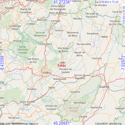
Sátão GPS coordinates[2]
40° 44' 30.372" North, 7° 43' 58.26" West
| Map corner | latitude | longitude |
|---|---|---|
| Upper-left | 41.27236°, | -8.43598° |
| Center: | 40.74177°, | -7.73285° |
| Lower-right: | 40.20691°, | -7.02973° |
| Map W x H: | 118.5×118.5 km | = 73.6×73.6mi |
| max Lat: | 42.11337° ⇑34.6% North |
| Sátão: | 40.74177° |
| min Lat: | ⇓65.4% South 32.6448° |
| min Long | Sátão | max Long |
| -31.17847° | -7.73285° | -6.27308° |
| W 87.1%⇐ | ⇒12.9% E |
Elevation
Elevation of Sátão is 606 m = 1988 ft, and this is 429 m = 1407 ft above average elevation for this country.
| Max E: |
1008 m = 3307 ft | 4.8% |
| Sátão | 606 m 1988 ft | |
| Avg. | 177 m = 581 ft | |
Min E: |
-128 m = -420 ft | 95.2% |
See also: Portugal elevation on elevation.city.
Geographical zone
Sátão is located in North temperate zone (between Tropic of Cancer and the Arctic Circle). Distance of this Northern Tropic circle is 1924.1 km =1195.6 mi to South.| Distance of | km | miles | from Sátão |
|---|---|---|---|
| North Pole | 5477 | 3403.2 | to North |
| Arctic Circle | 2871.1 | 1784 | to North |
| Tropic Cancer | 1924.1 | 1195.6 | to South |
| Equator | 4530.1 | 2814.9 | to South |


Nearby cities:
15 places around Sátão: (largest is in red/bold)
• Abraveses
17.2 km =10.7 mi,  247°
247°
• Aguiar da Beira
18 km =11.2 mi,  62°
62°
• Campo
15.7 km =9.8 mi,  257°
257°
• Castro Daire
24.3 km =15.1 mi,  315°
315°
• Fornos de Algodres
20.6 km =12.8 mi,  127°
127°
• Mangualde
15.5 km =9.6 mi,  188°
188°
• Mesquitela
17.4 km =10.8 mi,  183°
183°
• Moimenta da Beira
28.6 km =17.8 mi,  19°
19°
• Nelas
25.4 km =15.8 mi,  203°
203°
• Parada de Gonta
28.2 km =17.5 mi,  231°
231°
• Rio de Loba
14.8 km =9.2 mi,  235°
235°
• Rua
26.4 km =16.4 mi,  30°
30°
• Sernancelhe
26.7 km =16.6 mi,  49°
49°
• Vila Nova de Paiva
12.4 km =7.7 mi,  1°
1°
• Viseu
17.4 km =10.8 mi, 238°
Sources, notices
• [Note1] Compared only with cities in Portugal existing in our database
• [Src1] Map data: © OpenStreetMap contributors (CC-BY-SA)
• [Src2] Other city data from geonames.org with taken over terms of usage.
• [Src3] Geographical zone / Annual Mean Temperature by Robert A. Rohde @ Wikipedia
