Negreiros geodata
Negreiros (Braga) is a populated place; located in Portugal in Europe/Lisbon (GMT+1) time zone. With population of 2,364 people, there are 623 cities with bigger population in this country. Compared to other cities in Portugal, 89.4% of cities are located further ↓South; 54.3% of cities are located further →East and 51.7% of cities have lower elevation than Negreiros. Note1


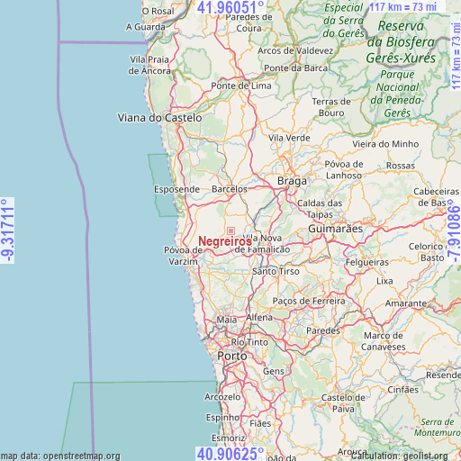
Negreiros GPS coordinates[2]
41° 26' 7.872" North, 8° 36' 50.328" West
| Map corner | latitude | longitude |
|---|---|---|
| Upper-left | 41.96051°, | -9.31711° |
| Center: | 41.43552°, | -8.61398° |
| Lower-right: | 40.90625°, | -7.91086° |
| Map W x H: | 117.2×117.2 km | = 72.8×72.8mi |
| max Lat: | 42.11337° ⇑10.6% North |
| Negreiros: | 41.43552° |
| min Lat: | ⇓89.4% South 32.6448° |
| min Long | Negreiros | max Long |
| -31.17847° | -8.61398° | -6.27308° |
| W 45.7%⇐ | ⇒54.3% E |
Elevation
Elevation of Negreiros is 118 m = 387 ft, and this is 59 m = 194 ft below average elevation for this country.
| Max E: |
1008 m = 3307 ft | 48.3% |
| Avg. | 177 m = 581 ft | |
| Negreiros | 118 m = 387 ft | |
Min E: |
-128 m = -420 ft | 51.7% |
See also: Portugal elevation on elevation.city.
Geographical zone
Negreiros is located in North temperate zone (between Tropic of Cancer and the Arctic Circle). Distance of this Northern Tropic circle is 2001.3 km =1243.5 mi to South.| Distance of | km | miles | from Negreiros |
|---|---|---|---|
| North Pole | 5399.9 | 3355.3 | to North |
| Arctic Circle | 2794 | 1736.1 | to North |
| Tropic Cancer | 2001.3 | 1243.5 | to South |
| Equator | 4607.2 | 2862.8 | to South |


Nearby cities:
15 places around Negreiros: (largest is in red/bold)
• Arcos
6.2 km =3.9 mi,  225°
225°
• Balazar
3.6 km =2.2 mi,  193°
193°
• Calendário
7.9 km =4.9 mi,  116°
116°
• Chavão
2.1 km =1.3 mi,  28°
28°
• Cristelo
8.5 km =5.3 mi,  305°
305°
• Faria
7.1 km =4.4 mi,  317°
317°
• Fradelos
7.6 km =4.7 mi,  170°
170°
• Gueral
2.9 km =1.8 mi,  333°
333°
• Macieira de Rates
1.8 km =1.1 mi,  289°
289°
• Paradela
6.3 km =3.9 mi,  298°
298°
• Ribeirão
9.2 km =5.7 mi,  155°
155°
• Rio Mau
6.5 km =4 mi,  237°
237°
• Vila Nova de Famalicão
8.4 km =5.2 mi,  111°
111°
• Vilar de Figos
5.6 km =3.5 mi, 323°
• Várzea
9.2 km =5.7 mi,  15°
15°
Sources, notices
• [Note1] Compared only with cities in Portugal existing in our database
• [Src1] Map data: © OpenStreetMap contributors (CC-BY-SA)
• [Src2] Other city data from geonames.org with taken over terms of usage.
• [Src3] Geographical zone / Annual Mean Temperature by Robert A. Rohde @ Wikipedia
