Paradela geodata
Paradela (Braga) is a populated place; located in Portugal in Europe/Lisbon (GMT+1) time zone. With population of 850 people, there are 777 cities with bigger population in this country. Compared to other cities in Portugal, 90.6% of cities are located further ↓South; 61.5% of cities are located further →East and 76.4% of cities have higher elevation than Paradela. Note1


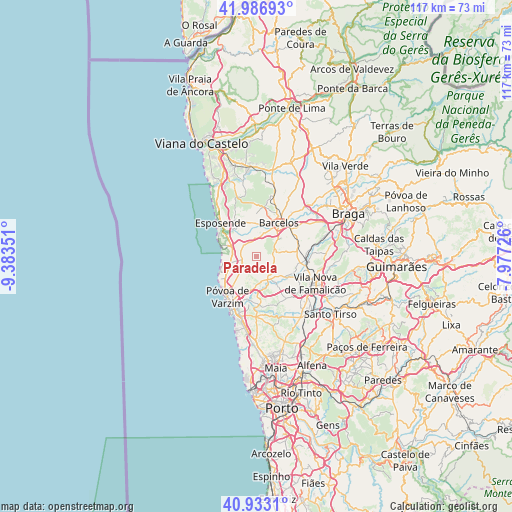
Paradela GPS coordinates[2]
41° 27' 43.776" North, 8° 40' 49.368" West
| Map corner | latitude | longitude |
|---|---|---|
| Upper-left | 41.98693°, | -9.38351° |
| Center: | 41.46216°, | -8.68038° |
| Lower-right: | 40.9331°, | -7.97726° |
| Map W x H: | 117.2×117.2 km | = 72.8×72.8mi |
| max Lat: | 42.11337° ⇑9.4% North |
| Paradela: | 41.46216° |
| min Lat: | ⇓90.6% South 32.6448° |
| min Long | Paradela | max Long |
| -31.17847° | -8.68038° | -6.27308° |
| W 38.5%⇐ | ⇒61.5% E |
Elevation
Elevation of Paradela is 38 m = 125 ft, and this is 139 m = 456 ft below average elevation for this country.
| Max E: |
1008 m = 3307 ft | 76.4% |
| Avg. | 177 m = 581 ft | |
| Paradela | 38 m = 125 ft | |
Min E: |
-128 m = -420 ft | 23.6% |
See also: Portugal elevation on elevation.city.
Geographical zone
Paradela is located in North temperate zone (between Tropic of Cancer and the Arctic Circle). Distance of this Northern Tropic circle is 2004.2 km =1245.4 mi to South.| Distance of | km | miles | from Paradela |
|---|---|---|---|
| North Pole | 5396.9 | 3353.5 | to North |
| Arctic Circle | 2791 | 1734.2 | to North |
| Tropic Cancer | 2004.2 | 1245.4 | to South |
| Equator | 4610.2 | 2864.6 | to South |


Nearby cities:
15 places around Paradela: (largest is in red/bold)
• Apúlia
7.4 km =4.6 mi,  290°
290°
• Arcos
7.4 km =4.6 mi,  171°
171°
• Barqueiros
5.4 km =3.4 mi,  306°
306°
• Chavão
6.6 km =4.1 mi,  99°
99°
• Cristelo
2.4 km =1.5 mi,  323°
323°
• Estela
6.1 km =3.8 mi,  256°
256°
• Faria
2.4 km =1.5 mi,  17°
17°
• Fornelos
6.2 km =3.9 mi,  2°
2°
• Gueral
4.3 km =2.7 mi, 95°
• Macieira de Rates
4.5 km =2.8 mi,  121°
121°
• Mariz
7.4 km =4.6 mi,  6°
6°
• Negreiros
6.3 km =3.9 mi, 118°
• Rio Mau
6.4 km =4 mi,  179°
179°
• Vila Seca
4.3 km =2.7 mi,  354°
354°
• Vilar de Figos
2.7 km =1.7 mi,  56°
56°
Sources, notices
• [Note1] Compared only with cities in Portugal existing in our database
• [Src1] Map data: © OpenStreetMap contributors (CC-BY-SA)
• [Src2] Other city data from geonames.org with taken over terms of usage.
• [Src3] Geographical zone / Annual Mean Temperature by Robert A. Rohde @ Wikipedia
