Balazar geodata
Balazar (Porto) is a populated place; located in Portugal in Europe/Lisbon (GMT+1) time zone. With population of 2,543 people, there are 612 cities with bigger population in this country. Compared to other cities in Portugal, 88% of cities are located further ↓South; 55.4% of cities are located further →East and 64.3% of cities have higher elevation than Balazar. Note1


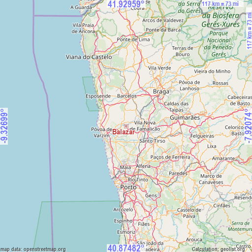
Balazar GPS coordinates[2]
41° 24' 15.66" North, 8° 37' 25.896" West
| Map corner | latitude | longitude |
|---|---|---|
| Upper-left | 41.92959°, | -9.32699° |
| Center: | 41.40435°, | -8.62386° |
| Lower-right: | 40.87482°, | -7.92074° |
| Map W x H: | 117.3×117.3 km | = 72.9×72.9mi |
| max Lat: | 42.11337° ⇑12% North |
| Balazar: | 41.40435° |
| min Lat: | ⇓88% South 32.6448° |
| min Long | Balazar | max Long |
| -31.17847° | -8.62386° | -6.27308° |
| W 44.6%⇐ | ⇒55.4% E |
Elevation
Elevation of Balazar is 64 m = 210 ft, and this is 113 m = 371 ft below average elevation for this country.
| Max E: |
1008 m = 3307 ft | 64.3% |
| Avg. | 177 m = 581 ft | |
| Balazar | 64 m = 210 ft | |
Min E: |
-128 m = -420 ft | 35.7% |
See also: Portugal elevation on elevation.city.
Geographical zone
Balazar is located in North temperate zone (between Tropic of Cancer and the Arctic Circle). Distance of this Northern Tropic circle is 1997.8 km =1241.4 mi to South.| Distance of | km | miles | from Balazar |
|---|---|---|---|
| North Pole | 5403.3 | 3357.5 | to North |
| Arctic Circle | 2797.4 | 1738.2 | to North |
| Tropic Cancer | 1997.8 | 1241.4 | to South |
| Equator | 4603.7 | 2860.6 | to South |


Nearby cities:
15 places around Balazar: (largest is in red/bold)
• Arcos
3.7 km =2.3 mi,  255°
255°
• Beiriz de Baixo
8.4 km =5.2 mi, 264°
• Calendário
7.9 km =4.9 mi,  90°
90°
• Chavão
5.6 km =3.5 mi,  18°
18°
• Ferreiros
8.6 km =5.3 mi,  134°
134°
• Fradelos
4.5 km =2.8 mi,  152°
152°
• Gueral
6 km =3.7 mi,  355°
355°
• Macieira de Rates
4.2 km =2.6 mi,  347°
347°
• Negreiros
3.6 km =2.2 mi,  13°
13°
• Paradela
8 km =5 mi,  323°
323°
• Ribeirão
6.7 km =4.2 mi,  135°
135°
• Rio Mau
4.7 km =2.9 mi,  269°
269°
• Vairão
8.7 km =5.4 mi,  204°
204°
• Vila Nova de Famalicão
8.7 km =5.4 mi, 87°
• Vilar de Figos
8.3 km =5.2 mi,  342°
342°
Sources, notices
• [Note1] Compared only with cities in Portugal existing in our database
• [Src1] Map data: © OpenStreetMap contributors (CC-BY-SA)
• [Src2] Other city data from geonames.org with taken over terms of usage.
• [Src3] Geographical zone / Annual Mean Temperature by Robert A. Rohde @ Wikipedia
