Várzea geodata
Várzea (Braga) is a populated place; located in Portugal in Europe/Lisbon (GMT+1) time zone. With population of 1,904 people, there are 658 cities with bigger population in this country. Compared to other cities in Portugal, 93% of cities are located further ↓South; 52% of cities are located further →East and 75.2% of cities have higher elevation than Várzea. Note1


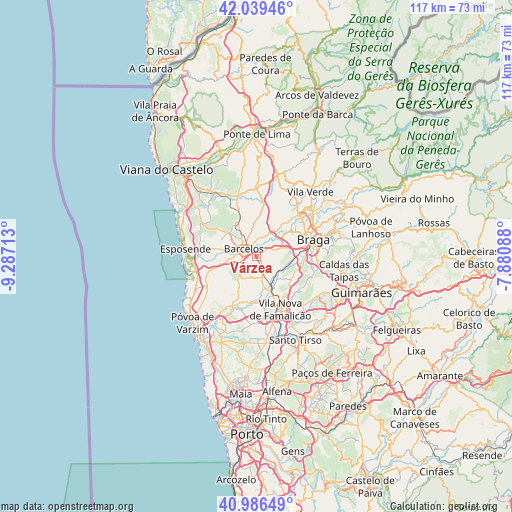
Várzea GPS coordinates[2]
41° 30' 54.432" North, 8° 35' 2.4" West
| Map corner | latitude | longitude |
|---|---|---|
| Upper-left | 42.03946°, | -9.28713° |
| Center: | 41.51512°, | -8.584° |
| Lower-right: | 40.98649°, | -7.88088° |
| Map W x H: | 117.1×117.1 km | = 72.8×72.8mi |
| max Lat: | 42.11337° ⇑7% North |
| Várzea: | 41.51512° |
| min Lat: | ⇓93% South 32.6448° |
| min Long | Várzea | max Long |
| -31.17847° | -8.584° | -6.27308° |
| W 48%⇐ | ⇒52% E |
Elevation
Elevation of Várzea is 40 m = 131 ft, and this is 137 m = 449 ft below average elevation for this country.
| Max E: |
1008 m = 3307 ft | 75.2% |
| Avg. | 177 m = 581 ft | |
| Várzea | 40 m = 131 ft | |
Min E: |
-128 m = -420 ft | 24.8% |
See also: Portugal elevation on elevation.city.
Geographical zone
Várzea is located in North temperate zone (between Tropic of Cancer and the Arctic Circle). Distance of this Northern Tropic circle is 2010.1 km =1249 mi to South.| Distance of | km | miles | from Várzea |
|---|---|---|---|
| North Pole | 5391 | 3349.8 | to North |
| Arctic Circle | 2785.1 | 1730.6 | to North |
| Tropic Cancer | 2010.1 | 1249 | to South |
| Equator | 4616 | 2868.2 | to South |


Nearby cities:
15 places around Várzea: (largest is in red/bold)
• Barcelos
3.4 km =2.1 mi,  302°
302°
• Chavão
7.1 km =4.4 mi,  192°
192°
• Faria
8.1 km =5 mi,  243°
243°
• Fornelos
7.8 km =4.8 mi,  272°
272°
• Galegos
5.4 km =3.4 mi,  10°
10°
• Gueral
7.3 km =4.5 mi,  211°
211°
• Macieira de Rates
9.3 km =5.8 mi, 206°
• Mariz
7.4 km =4.6 mi,  281°
281°
• Negreiros
9.2 km =5.7 mi,  195°
195°
• Perelhal
9 km =5.6 mi, 281°
• Tebosa
9.1 km =5.7 mi,  113°
113°
• Vila Frescainha
5.3 km =3.3 mi, 299°
• Vila Seca
8.6 km =5.3 mi,  258°
258°
• Vilar de Figos
7.3 km =4.5 mi,  232°
232°
• Vilaça
8.4 km =5.2 mi,  87°
87°
Sources, notices
• [Note1] Compared only with cities in Portugal existing in our database
• [Src1] Map data: © OpenStreetMap contributors (CC-BY-SA)
• [Src2] Other city data from geonames.org with taken over terms of usage.
• [Src3] Geographical zone / Annual Mean Temperature by Robert A. Rohde @ Wikipedia
