Mariz geodata
Mariz (Braga) is a populated place; located in Portugal in Europe/Lisbon (GMT+1) time zone. With population of 1,208 people, there are 724 cities with bigger population in this country. Compared to other cities in Portugal, 93.9% of cities are located further ↓South; 60.6% of cities are located further →East and 64.7% of cities have higher elevation than Mariz. Note1


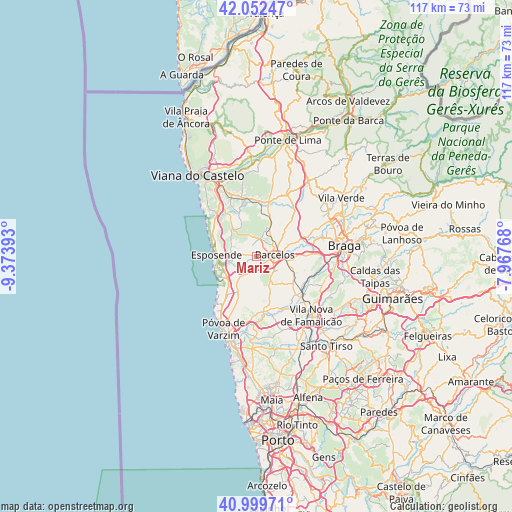
Mariz GPS coordinates[2]
41° 31' 41.628" North, 8° 40' 14.916" West
| Map corner | latitude | longitude |
|---|---|---|
| Upper-left | 42.05247°, | -9.37393° |
| Center: | 41.52823°, | -8.67081° |
| Lower-right: | 40.99971°, | -7.96768° |
| Map W x H: | 117.1×117.1 km | = 72.8×72.8mi |
| max Lat: | 42.11337° ⇑6.1% North |
| Mariz: | 41.52823° |
| min Lat: | ⇓93.9% South 32.6448° |
| min Long | Mariz | max Long |
| -31.17847° | -8.67081° | -6.27308° |
| W 39.4%⇐ | ⇒60.6% E |
Elevation
Elevation of Mariz is 63 m = 207 ft, and this is 114 m = 374 ft below average elevation for this country.
| Max E: |
1008 m = 3307 ft | 64.7% |
| Avg. | 177 m = 581 ft | |
| Mariz | 63 m = 207 ft | |
Min E: |
-128 m = -420 ft | 35.3% |
See also: Portugal elevation on elevation.city.
Geographical zone
Mariz is located in North temperate zone (between Tropic of Cancer and the Arctic Circle). Distance of this Northern Tropic circle is 2011.6 km =1249.9 mi to South.| Distance of | km | miles | from Mariz |
|---|---|---|---|
| North Pole | 5389.6 | 3348.9 | to North |
| Arctic Circle | 2783.7 | 1729.7 | to North |
| Tropic Cancer | 2011.6 | 1249.9 | to South |
| Equator | 4617.5 | 2869.2 | to South |


Nearby cities:
15 places around Mariz: (largest is in red/bold)
• Apúlia e Fão
8.7 km =5.4 mi,  257°
257°
• Barcelos
4.4 km =2.7 mi,  84°
84°
• Barqueiros
6.6 km =4.1 mi,  230°
230°
• Cristelo
5.9 km =3.7 mi,  202°
202°
• Faria
5 km =3.1 mi,  180°
180°
• Fornelos
1.3 km =0.8 mi, 204°
• Gandra
7.6 km =4.7 mi, 264°
• Gueral
8.5 km =5.3 mi,  156°
156°
• Paradela
7.4 km =4.6 mi,  186°
186°
• Perelhal
1.6 km =1 mi,  280°
280°
• Vila Cova
4.6 km =2.9 mi,  303°
303°
• Vila Frescainha
2.8 km =1.7 mi,  66°
66°
• Vila Seca
3.3 km =2.1 mi, 201°
• Vilar de Figos
6 km =3.7 mi,  166°
166°
• Várzea
7.4 km =4.6 mi,  101°
101°
Sources, notices
• [Note1] Compared only with cities in Portugal existing in our database
• [Src1] Map data: © OpenStreetMap contributors (CC-BY-SA)
• [Src2] Other city data from geonames.org with taken over terms of usage.
• [Src3] Geographical zone / Annual Mean Temperature by Robert A. Rohde @ Wikipedia
