Fornelos geodata
Fornelos (Braga) is a populated place; located in Portugal in Europe/Lisbon (GMT+1) time zone. With population of 803 people, there are 782 cities with bigger population in this country. Compared to other cities in Portugal, 93.2% of cities are located further ↓South; 61.3% of cities are located further →East and 76.9% of cities have higher elevation than Fornelos. Note1


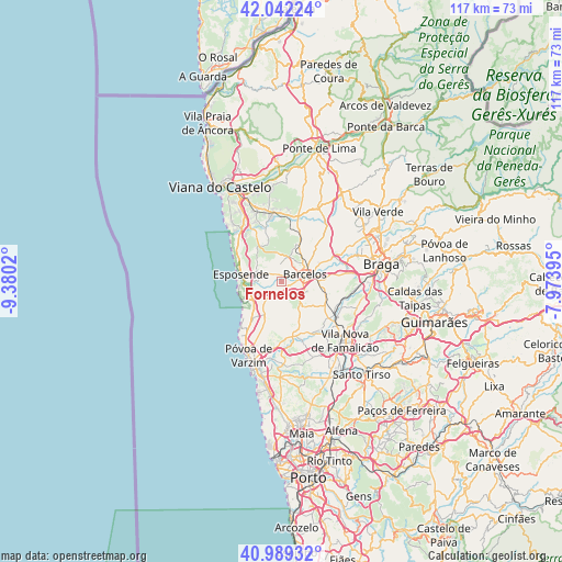
Fornelos GPS coordinates[2]
41° 31' 4.512" North, 8° 40' 37.488" West
| Map corner | latitude | longitude |
|---|---|---|
| Upper-left | 42.04224°, | -9.3802° |
| Center: | 41.51792°, | -8.67708° |
| Lower-right: | 40.98932°, | -7.97395° |
| Map W x H: | 117.1×117.1 km | = 72.8×72.8mi |
| max Lat: | 42.11337° ⇑6.8% North |
| Fornelos: | 41.51792° |
| min Lat: | ⇓93.2% South 32.6448° |
| min Long | Fornelos | max Long |
| -31.17847° | -8.67708° | -6.27308° |
| W 38.7%⇐ | ⇒61.3% E |
Elevation
Elevation of Fornelos is 37 m = 121 ft, and this is 140 m = 459 ft below average elevation for this country.
| Max E: |
1008 m = 3307 ft | 76.9% |
| Avg. | 177 m = 581 ft | |
| Fornelos | 37 m = 121 ft | |
Min E: |
-128 m = -420 ft | 23.1% |
See also: Portugal elevation on elevation.city.
Geographical zone
Fornelos is located in North temperate zone (between Tropic of Cancer and the Arctic Circle). Distance of this Northern Tropic circle is 2010.4 km =1249.2 mi to South.| Distance of | km | miles | from Fornelos |
|---|---|---|---|
| North Pole | 5390.7 | 3349.6 | to North |
| Arctic Circle | 2784.8 | 1730.4 | to North |
| Tropic Cancer | 2010.4 | 1249.2 | to South |
| Equator | 4616.4 | 2868.5 | to South |


Nearby cities:
15 places around Fornelos: (largest is in red/bold)
• Apúlia e Fão
8 km =5 mi,  265°
265°
• Barcelos
5.1 km =3.2 mi,  72°
72°
• Barqueiros
5.5 km =3.4 mi,  236°
236°
• Cristelo
4.6 km =2.9 mi,  202°
202°
• Faria
3.9 km =2.4 mi,  173°
173°
• Gandra
7.1 km =4.4 mi, 273°
• Gueral
7.7 km =4.8 mi,  148°
148°
• Mariz
1.3 km =0.8 mi,  24°
24°
• Paradela
6.2 km =3.9 mi,  182°
182°
• Perelhal
1.8 km =1.1 mi,  323°
323°
• Vila Cova
4.9 km =3 mi, 318°
• Vila Frescainha
3.9 km =2.4 mi,  53°
53°
• Vila Seca
2.1 km =1.3 mi, 199°
• Vilar de Figos
5.1 km =3.2 mi,  157°
157°
• Várzea
7.8 km =4.8 mi,  92°
92°
Sources, notices
• [Note1] Compared only with cities in Portugal existing in our database
• [Src1] Map data: © OpenStreetMap contributors (CC-BY-SA)
• [Src2] Other city data from geonames.org with taken over terms of usage.
• [Src3] Geographical zone / Annual Mean Temperature by Robert A. Rohde @ Wikipedia
