Lagoaça geodata
Lagoaça (Bragança) is a populated place; located in Portugal in Europe/Lisbon (GMT+1) time zone. With population of 617 people, there are 807 cities with bigger population in this country. Compared to other cities in Portugal, 78.5% of cities are located further ↓South; 99.5% of cities are located further ←West and 97.4% of cities have lower elevation than Lagoaça. Note1


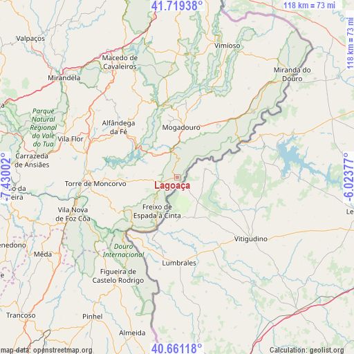
Lagoaça GPS coordinates[2]
41° 11' 32.712" North, 6° 43' 36.804" West
| Map corner | latitude | longitude |
|---|---|---|
| Upper-left | 41.71938°, | -7.43002° |
| Center: | 41.19242°, | -6.72689° |
| Lower-right: | 40.66118°, | -6.02377° |
| Map W x H: | 117.7×117.7 km | = 73.1×73.1mi |
| max Lat: | 42.11337° ⇑21.5% North |
| Lagoaça: | 41.19242° |
| min Lat: | ⇓78.5% South 32.6448° |
| min Long | Lagoaça | max Long |
| -31.17847° | -6.72689° | -6.27308° |
| W 99.5%⇐ | ⇒0.5% E |
Elevation
Elevation of Lagoaça is 705 m = 2313 ft, and this is 528 m = 1732 ft above average elevation for this country.
| Max E: |
1008 m = 3307 ft | 2.6% |
| Lagoaça | 705 m 2313 ft | |
| Avg. | 177 m = 581 ft | |
Min E: |
-128 m = -420 ft | 97.4% |
See also: Portugal elevation on elevation.city.
Geographical zone
Lagoaça is located in North temperate zone (between Tropic of Cancer and the Arctic Circle). Distance of this Northern Tropic circle is 1974.2 km =1226.7 mi to South.| Distance of | km | miles | from Lagoaça |
|---|---|---|---|
| North Pole | 5426.9 | 3372.1 | to North |
| Arctic Circle | 2821 | 1752.9 | to North |
| Tropic Cancer | 1974.2 | 1226.7 | to South |
| Equator | 4580.2 | 2846 | to South |


Nearby cities:
15 places around Lagoaça: (largest is in red/bold)
• Alfândega da Fé
25.8 km =16 mi,  310°
310°
• Belver
46.3 km =28.8 mi,  277°
277°
• Carrazeda de Anciães
48.9 km =30.4 mi, 276°
• Custoias
50.7 km =31.5 mi,  258°
258°
• Figueira de Castelo Rodrigo
38.8 km =24.1 mi,  210°
210°
• Freixo de Espada à Cinta
13.2 km =8.2 mi, 210°
• Freixo de Numão
43.7 km =27.2 mi,  251°
251°
• Macedo de Cavaleiros
43.1 km =26.8 mi,  333°
333°
• Mirandela
50.5 km =31.4 mi, 310°
• Mogadouro
16.5 km =10.3 mi,  4°
4°
• Sendim
33.2 km =20.6 mi,  49°
49°
• Torre de Moncorvo
27.4 km =17 mi,  265°
265°
• Vila Flor
38 km =23.6 mi,  289°
289°
• Vila Nova de Foz Côa
36.8 km =22.9 mi, 250°
• Vimioso
46.7 km =29 mi,  20°
20°
Sources, notices
• [Note1] Compared only with cities in Portugal existing in our database
• [Src1] Map data: © OpenStreetMap contributors (CC-BY-SA)
• [Src2] Other city data from geonames.org with taken over terms of usage.
• [Src3] Geographical zone / Annual Mean Temperature by Robert A. Rohde @ Wikipedia
