Sendim geodata
Sendim (Bragança) is a populated place; located in Portugal in Europe/Lisbon (GMT+1) time zone. With population of 1,487 people, there are 690 cities with bigger population in this country. Compared to other cities in Portugal, 87.1% of cities are located further ↓South; 99.9% of cities are located further ←West and 98% of cities have lower elevation than Sendim. Note1


Sendim GPS coordinates[2]
41° 23' 14.604" North, 6° 25' 34.5" West
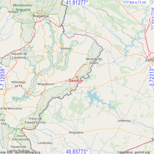
| Map corner | latitude | longitude |
|---|---|---|
| Upper-left | 41.91277°, | -7.12938° |
| Center: | 41.38739°, | -6.42625° |
| Lower-right: | 40.85773°, | -5.72313° |
| Map W x H: | 117.3×117.3 km | = 72.9×72.9mi |
| max Lat: | 42.11337° ⇑12.9% North |
| Sendim: | 41.38739° |
| min Lat: | ⇓87.1% South 32.6448° |
| min Long | Sendim | max Long |
| -31.17847° | -6.42625° | -6.27308° |
| W 99.9%⇐ | ⇒0.099999999999994% E |
Elevation
Elevation of Sendim is 718 m = 2356 ft, and this is 541 m = 1775 ft above average elevation for this country.
| Max E: |
1008 m = 3307 ft | 2% |
| Sendim | 718 m 2356 ft | |
| Avg. | 177 m = 581 ft | |
Min E: |
-128 m = -420 ft | 98% |
See also: Portugal elevation on elevation.city.
Geographical zone
Sendim is located in North temperate zone (between Tropic of Cancer and the Arctic Circle). Distance of this Northern Tropic circle is 1995.9 km =1240.2 mi to South.| Distance of | km | miles | from Sendim |
|---|---|---|---|
| North Pole | 5405.2 | 3358.6 | to North |
| Arctic Circle | 2799.3 | 1739.4 | to North |
| Tropic Cancer | 1995.9 | 1240.2 | to South |
| Equator | 4601.8 | 2859.4 | to South |


Nearby cities:
15 places around Sendim: (largest is in red/bold)
• Alfândega da Fé
44.9 km =27.9 mi,  263°
263°
• Bragança
54.1 km =33.6 mi,  329°
329°
• Figueira de Castelo Rodrigo
71.1 km =44.2 mi,  219°
219°
• Freixo de Espada à Cinta
45.8 km =28.5 mi, 223°
• Lagoaça
33.2 km =20.6 mi,  229°
229°
• Macedo de Cavaleiros
47.6 km =29.6 mi,  290°
290°
• Miranda do Douro
17.6 km =10.9 mi,  46°
46°
• Mirandela
64.4 km =40 mi,  279°
279°
• Mogadouro
24.4 km =15.2 mi, 257°
• Samil
51.3 km =31.9 mi, 327°
• Torre de Moncorvo
57.5 km =35.7 mi,  245°
245°
• Vila Flor
61.3 km =38.1 mi, 261°
• Vila Nova de Foz Côa
68.8 km =42.8 mi,  240°
240°
• Vimioso
23.5 km =14.6 mi,  338°
338°
• Vinhais
69.2 km =43 mi,  315°
315°
Sources, notices
• [Note1] Compared only with cities in Portugal existing in our database
• [Src1] Map data: © OpenStreetMap contributors (CC-BY-SA)
• [Src2] Other city data from geonames.org with taken over terms of usage.
• [Src3] Geographical zone / Annual Mean Temperature by Robert A. Rohde @ Wikipedia
