Estela geodata
Estela (Porto) is a populated place; located in Portugal in Europe/Lisbon (GMT+1) time zone. With population of 2,307 people, there are 627 cities with bigger population in this country. Compared to other cities in Portugal, 89.9% of cities are located further ↓South; 65.8% of cities are located further →East and 82.9% of cities have higher elevation than Estela. Note1


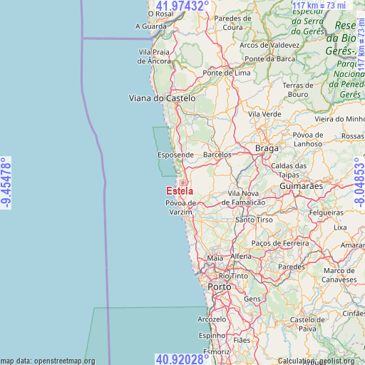
Estela GPS coordinates[2]
41° 26' 57.984" North, 8° 45' 5.976" West
| Map corner | latitude | longitude |
|---|---|---|
| Upper-left | 41.97432°, | -9.45478° |
| Center: | 41.44944°, | -8.75166° |
| Lower-right: | 40.92028°, | -8.04853° |
| Map W x H: | 117.2×117.2 km | = 72.8×72.8mi |
| max Lat: | 42.11337° ⇑10.1% North |
| Estela: | 41.44944° |
| min Lat: | ⇓89.9% South 32.6448° |
| min Long | Estela | max Long |
| -31.17847° | -8.75166° | -6.27308° |
| W 34.2%⇐ | ⇒65.8% E |
Elevation
Elevation of Estela is 27 m = 89 ft, and this is 150 m = 492 ft below average elevation for this country.
| Max E: |
1008 m = 3307 ft | 82.9% |
| Avg. | 177 m = 581 ft | |
| Estela | 27 m = 89 ft | |
Min E: |
-128 m = -420 ft | 17.1% |
See also: Portugal elevation on elevation.city.
Geographical zone
Estela is located in North temperate zone (between Tropic of Cancer and the Arctic Circle). Distance of this Northern Tropic circle is 2002.8 km =1244.5 mi to South.| Distance of | km | miles | from Estela |
|---|---|---|---|
| North Pole | 5398.3 | 3354.3 | to North |
| Arctic Circle | 2792.4 | 1735.1 | to North |
| Tropic Cancer | 2002.8 | 1244.5 | to South |
| Equator | 4608.7 | 2863.7 | to South |


Nearby cities:
15 places around Estela: (largest is in red/bold)
• Aguçadoura
3 km =1.9 mi,  227°
227°
• Amorim
4.9 km =3 mi,  178°
178°
• Apúlia
4.1 km =2.5 mi,  345°
345°
• Apúlia e Fão
7.2 km =4.5 mi, 345°
• Aver-o-Mar
5.4 km =3.4 mi,  205°
205°
• Barqueiros
4.9 km =3 mi,  19°
19°
• Beiriz de Baixo
6.2 km =3.9 mi,  158°
158°
• Cristelo
5.6 km =3.5 mi,  53°
53°
• Faria
7.6 km =4.7 mi,  60°
60°
• Gandra
8.1 km =5 mi, 353°
• Paradela
6.1 km =3.8 mi,  76°
76°
• Pedroso
4.3 km =2.7 mi, 176°
• Póvoa de Varzim
7.4 km =4.6 mi,  187°
187°
• Rio Mau
7.8 km =4.8 mi,  130°
130°
• Vila Seca
7.9 km =4.9 mi,  44°
44°
Sources, notices
• [Note1] Compared only with cities in Portugal existing in our database
• [Src1] Map data: © OpenStreetMap contributors (CC-BY-SA)
• [Src2] Other city data from geonames.org with taken over terms of usage.
• [Src3] Geographical zone / Annual Mean Temperature by Robert A. Rohde @ Wikipedia
