Pedroso geodata
Pedroso (Porto) is a populated place; located in Portugal in Europe/Lisbon (GMT+1) time zone. With population of 18,963 people, there are 105 cities with bigger population in this country. Compared to other cities in Portugal, 88.7% of cities are located further ↓South; 65.6% of cities are located further →East and 78.1% of cities have higher elevation than Pedroso. Note1


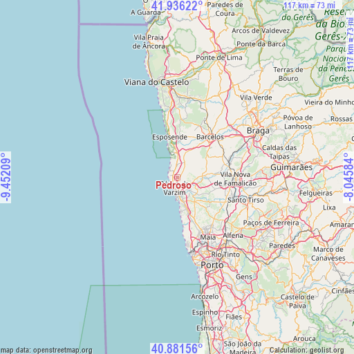
Pedroso GPS coordinates[2]
41° 24' 39.708" North, 8° 44' 56.292" West
| Map corner | latitude | longitude |
|---|---|---|
| Upper-left | 41.93622°, | -9.45209° |
| Center: | 41.41103°, | -8.74897° |
| Lower-right: | 40.88156°, | -8.04584° |
| Map W x H: | 117.3×117.3 km | = 72.9×72.9mi |
| max Lat: | 42.11337° ⇑11.3% North |
| Pedroso: | 41.41103° |
| min Lat: | ⇓88.7% South 32.6448° |
| min Long | Pedroso | max Long |
| -31.17847° | -8.74897° | -6.27308° |
| W 34.4%⇐ | ⇒65.6% E |
Elevation
Elevation of Pedroso is 35 m = 115 ft, and this is 142 m = 466 ft below average elevation for this country.
| Max E: |
1008 m = 3307 ft | 78.1% |
| Avg. | 177 m = 581 ft | |
| Pedroso | 35 m = 115 ft | |
Min E: |
-128 m = -420 ft | 21.9% |
See also: Portugal elevation on elevation.city.
Geographical zone
Pedroso is located in North temperate zone (between Tropic of Cancer and the Arctic Circle). Distance of this Northern Tropic circle is 1998.6 km =1241.9 mi to South.| Distance of | km | miles | from Pedroso |
|---|---|---|---|
| North Pole | 5402.6 | 3357 | to North |
| Arctic Circle | 2796.7 | 1737.8 | to North |
| Tropic Cancer | 1998.6 | 1241.9 | to South |
| Equator | 4604.5 | 2861.1 | to South |


Nearby cities:
15 places around Pedroso: (largest is in red/bold)
• Aguçadoura
3.3 km =2.1 mi,  312°
312°
• Amorim
0.7 km =0.4 mi,  190°
190°
• Apúlia
8.3 km =5.2 mi,  351°
351°
• Arcos
7 km =4.3 mi,  103°
103°
• Argivai
4.1 km =2.5 mi,  156°
156°
• Aver-o-Mar
2.6 km =1.6 mi,  257°
257°
• Barqueiros
9 km =5.6 mi,  9°
9°
• Beiriz de Baixo
2.6 km =1.6 mi,  126°
126°
• Cristelo
8.7 km =5.4 mi,  29°
29°
• Estela
4.3 km =2.7 mi,  356°
356°
• Paradela
8.1 km =5 mi,  45°
45°
• Póvoa de Varzim
3.3 km =2.1 mi,  201°
201°
• Rio Mau
5.8 km =3.6 mi, 97°
• Vila do Conde
6.4 km =4 mi,  177°
177°
• Árvore
8.4 km =5.2 mi, 162°
Sources, notices
• [Note1] Compared only with cities in Portugal existing in our database
• [Src1] Map data: © OpenStreetMap contributors (CC-BY-SA)
• [Src2] Other city data from geonames.org with taken over terms of usage.
• [Src3] Geographical zone / Annual Mean Temperature by Robert A. Rohde @ Wikipedia
