Vairão geodata
Vairão (Porto) is a populated place; located in Portugal in Europe/Lisbon (GMT+1) time zone. With population of 2,643 people, there are 603 cities with bigger population in this country. Compared to other cities in Portugal, 84.2% of cities are located further ↓South; 60% of cities are located further →East and 62.8% of cities have higher elevation than Vairão. Note1


Vairão GPS coordinates[2]
41° 19' 58.44" North, 8° 39' 59.652" West
| Map corner | latitude | longitude |
|---|---|---|
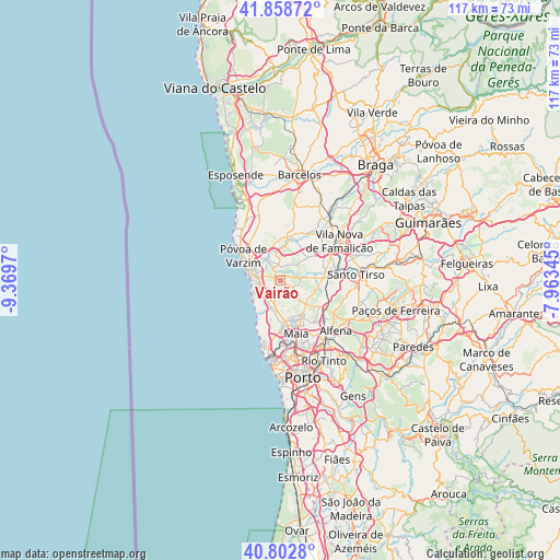
| Upper-left | 41.85872°, | -9.3697° |
| Center: | 41.3329°, | -8.66657° |
| Lower-right: | 40.8028°, | -7.96345° |
| Map W x H: | 117.4×117.4 km | = 72.9×72.9mi |
| max Lat: | 42.11337° ⇑15.8% North |
| Vairão: | 41.3329° |
| min Lat: | ⇓84.2% South 32.6448° |
| min Long | Vairão | max Long |
| -31.17847° | -8.66657° | -6.27308° |
| W 40%⇐ | ⇒60% E |
Elevation
Elevation of Vairão is 69 m = 226 ft, and this is 108 m = 354 ft below average elevation for this country.
| Max E: |
1008 m = 3307 ft | 62.8% |
| Avg. | 177 m = 581 ft | |
| Vairão | 69 m = 226 ft | |
Min E: |
-128 m = -420 ft | 37.2% |
See also: Portugal elevation on elevation.city.
Geographical zone
Vairão is located in North temperate zone (between Tropic of Cancer and the Arctic Circle). Distance of this Northern Tropic circle is 1989.9 km =1236.5 mi to South.| Distance of | km | miles | from Vairão |
|---|---|---|---|
| North Pole | 5411.3 | 3362.4 | to North |
| Arctic Circle | 2805.4 | 1743.2 | to North |
| Tropic Cancer | 1989.9 | 1236.5 | to South |
| Equator | 4595.8 | 2855.7 | to South |


Nearby cities:
15 places around Vairão: (largest is in red/bold)
• Anta
8.1 km =5 mi,  156°
156°
• Arcos
7 km =4.3 mi,  359°
359°
• Argivai
7.2 km =4.5 mi,  313°
313°
• Balazar
8.7 km =5.4 mi,  24°
24°
• Beiriz de Baixo
8.6 km =5.3 mi,  326°
326°
• Bougado
9.6 km =6 mi,  85°
85°
• Fradelos
6.9 km =4.3 mi,  55°
55°
• Gemunde
7.5 km =4.7 mi,  166°
166°
• Lavra
9.3 km =5.8 mi,  207°
207°
• Mindelo
5 km =3.1 mi,  246°
246°
• Ribeirão
8.8 km =5.5 mi,  69°
69°
• Rio Mau
8 km =5 mi,  351°
351°
• Trofa
8.9 km =5.5 mi, 86°
• Vila do Conde
6.9 km =4.3 mi,  289°
289°
• Árvore
4.4 km =2.7 mi,  279°
279°
Sources, notices
• [Note1] Compared only with cities in Portugal existing in our database
• [Src1] Map data: © OpenStreetMap contributors (CC-BY-SA)
• [Src2] Other city data from geonames.org with taken over terms of usage.
• [Src3] Geographical zone / Annual Mean Temperature by Robert A. Rohde @ Wikipedia
