Nemby geodata
Nemby (Central) is a populated place; located in Paraguay in America/Asuncion (GMT-4) time zone. With population of 94,641 people, there are 7 cities with bigger population in this country. Compared to other cities in Paraguay, 56.8% of cities are located further ↓South; 89.5% of cities are located further →East and 79.6% of cities have higher elevation than Nemby. Note1


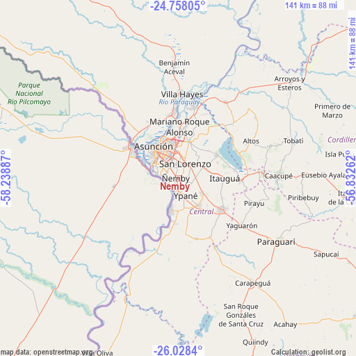
Nemby GPS coordinates[2]
25° 23' 41.64" South, 57° 32' 8.664" West
| Map corner | latitude | longitude |
|---|---|---|
| Upper-left | -24.75805°, | -58.23887° |
| Center: | -25.3949°, | -57.53574° |
| Lower-right: | -26.0284°, | -56.83262° |
| Map W x H: | 141.2×141.3 km | = 87.7×87.8mi |
| max Lat: | -19.91667° ⇑43.2% North |
| Nemby: | -25.3949° |
| min Lat: | ⇓56.8% South -27.38662° |
| min Long | Nemby | max Long |
| -60.78333° | -57.53574° | -54.30694° |
| W 10.5%⇐ | ⇒89.5% E |
Elevation
Elevation of Nemby is 109 m = 358 ft, and this is 60.7 m = 199 ft below average elevation for this country.
| Max E: |
658 m = 2159 ft | 79.6% |
| Avg. | 169.7 m = 557 ft | |
| Nemby | 109 m = 358 ft | |
Min E: |
46 m = 151 ft | 20.4% |
See also: Nemby elevation on elevation.city.
Geographical zone
Nemby is located in South temperate zone (between Tropic of Capricorn and the Antarctic Circle). Distance of this Southern Tropic circle is 217.7 km =135.3 mi to North.| Distance of | km | miles | from Nemby |
|---|---|---|---|
| Equator | 2823.6 | 1754.5 | to North |
| Tropic Capricorn | 217.7 | 135.3 | to North |
| Antarctic Circle | 4577.5 | 2844.3 | to South |
| South Pole | 7183.4 | 4463.6 | to South |


Nearby cities:
15 places around Nemby: (largest is in red/bold)
• Areguá
17.7 km =11 mi,  58°
58°
• Asunción
16.4 km =10.2 mi,  317°
317°
• Capiatá
10.1 km =6.3 mi, 64°
• Fernando de la Mora
6.4 km =4 mi,  12°
12°
• Guarambaré
13.4 km =8.3 mi,  143°
143°
• Itauguá
18.2 km =11.3 mi,  89°
89°
• Itá
20.6 km =12.8 mi,  124°
124°
• Lambaré
8.9 km =5.5 mi,  306°
306°
• Mariano Roque Alonso
20.8 km =12.9 mi,  1°
1°
• Nanawua
21.2 km =13.2 mi, 307°
• Nueva Italia
25 km =15.5 mi,  163°
163°
• San Antonio
3.2 km =2 mi,  201°
201°
• San Lorenzo
6.7 km =4.2 mi,  23°
23°
• Villa Elisa
6.5 km =4 mi,  297°
297°
• Ypacarai
24.8 km =15.4 mi, 93°
Sources, notices
• [Note1] Compared only with cities in Paraguay existing in our database
• [Src1] Map data: © OpenStreetMap contributors (CC-BY-SA)
• [Src2] Other city data from geonames.org with taken over terms of usage.
• [Src3] Geographical zone / Annual Mean Temperature by Robert A. Rohde @ Wikipedia
