Ypacarai geodata
Ypacarai (Central) is a populated place; located in Paraguay in America/Asuncion (GMT-4) time zone. With population of 9,655 people, there are 36 cities with bigger population in this country. Compared to other cities in Paraguay, 55.6% of cities are located further ↓South; 78.4% of cities are located further →East and 85.2% of cities have higher elevation than Ypacarai. Note1


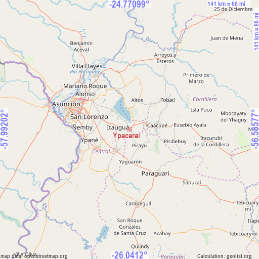
Ypacarai GPS coordinates[2]
25° 24' 27.972" South, 57° 17' 20.004" West
| Map corner | latitude | longitude |
|---|---|---|
| Upper-left | -24.77099°, | -57.99202° |
| Center: | -25.40777°, | -57.28889° |
| Lower-right: | -26.0412°, | -56.58577° |
| Map W x H: | 141.2×141.2 km | = 87.7×87.7mi |
| max Lat: | -19.91667° ⇑44.4% North |
| Ypacarai: | -25.40777° |
| min Lat: | ⇓55.6% South -27.38662° |
| min Long | Ypacarai | max Long |
| -60.78333° | -57.28889° | -54.30694° |
| W 21.6%⇐ | ⇒78.4% E |
Elevation
Elevation of Ypacarai is 91 m = 299 ft, and this is 78.7 m = 258 ft below average elevation for this country.
| Max E: |
658 m = 2159 ft | 85.2% |
| Avg. | 169.7 m = 557 ft | |
| Ypacarai | 91 m = 299 ft | |
Min E: |
46 m = 151 ft | 14.8% |
See also: Paraguay elevation on elevation.city.
Geographical zone
Ypacarai is located in South temperate zone (between Tropic of Capricorn and the Antarctic Circle). Distance of this Southern Tropic circle is 219.2 km =136.2 mi to North.| Distance of | km | miles | from Ypacarai |
|---|---|---|---|
| Equator | 2825.1 | 1755.4 | to North |
| Tropic Capricorn | 219.2 | 136.2 | to North |
| Antarctic Circle | 4576.1 | 2843.5 | to South |
| South Pole | 7182 | 4462.7 | to South |


Nearby cities:
15 places around Ypacarai: (largest is in red/bold)
• Altos
16.5 km =10.3 mi,  12°
12°
• Areguá
14.3 km =8.9 mi,  317°
317°
• Atyrá
18.5 km =11.5 mi,  39°
39°
• Caacupé
14.9 km =9.3 mi,  80°
80°
• Capiatá
16.8 km =10.4 mi,  290°
290°
• Fernando de la Mora
24.6 km =15.3 mi, 288°
• Guarambaré
19.1 km =11.9 mi,  241°
241°
• Itauguá
6.8 km =4.2 mi,  284°
284°
• Itá
13 km =8.1 mi,  217°
217°
• Nemby
24.8 km =15.4 mi,  273°
273°
• Pirayú
10.1 km =6.3 mi,  147°
147°
• Piribebuy
25.6 km =15.9 mi,  104°
104°
• San Bernardino
10.8 km =6.7 mi,  356°
356°
• San Lorenzo
23.4 km =14.5 mi, 288°
• Yaguarón
17.1 km =10.6 mi,  178°
178°
Sources, notices
• [Note1] Compared only with cities in Paraguay existing in our database
• [Src1] Map data: © OpenStreetMap contributors (CC-BY-SA)
• [Src2] Other city data from geonames.org with taken over terms of usage.
• [Src3] Geographical zone / Annual Mean Temperature by Robert A. Rohde @ Wikipedia
