Capitán Pablo Lagerenza geodata
Capitán Pablo Lagerenza (Alto Paraguay) is a populated place; located in Paraguay in America/Asuncion (GMT-4) time zone. With population of 1,200 people, there are 137 cities with bigger population in this country. Compared to other cities in Paraguay, 100% of cities are located further ↓South; 100% of cities are located further →East and 75.9% of cities have lower elevation than Capitán Pablo Lagerenza. Note1
Current local time in Capitán Pablo Lagerenza:
08:29 PM, ThursdayDifference from your time zone: hours


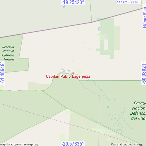
Capitán Pablo Lagerenza GPS coordinates[2]
19° 55' 0.012" South, 60° 46' 59.988" West
| Map corner | latitude | longitude |
|---|---|---|
| Upper-left | -19.25423°, | -61.48646° |
| Center: | -19.91667°, | -60.78333° |
| Lower-right: | -20.57635°, | -60.08021° |
| Map W x H: | 147×147 km | = 91.3×91.3mi |
| max Lat: | -19.91667° ⇑0% North |
| Capitán Pablo Lagerenza: | -19.91667° |
| min Lat: | ⇓100% South -27.38662° |
| min Long | Capitán Pablo | max Long |
| -60.78333° | -60.78333° | -54.30694° |
| W 0%⇐ | ⇒100% E |
Elevation
Elevation of Capitán Pablo Lagerenza is 204 m = 669 ft, and this is 34.3 m = 113 ft above average elevation for this country.
| Max E: |
658 m = 2159 ft | 24.1% |
| Capitán Pablo Lagerenza | 204 m 669 ft | |
| Avg. | 169.7 m = 557 ft | |
Min E: |
46 m = 151 ft | 75.9% |
See also: Paraguay elevation on elevation.city.
Geographical zone
Capitán Pablo Lagerenza is located in South Torrid zone (between Equator and Tropic of Capricorn). Distance of this Southern Tropic circle is 391.4 km =243.2 mi to South.| Distance of | km | miles | from Capitán Pablo Lagerenza |
|---|---|---|---|
| Equator | 2214.5 | 1376 | to North |
| Tropic Capricorn | 391.4 | 243.2 | to South |
| Antarctic Circle | 5186.6 | 3222.8 | to South |
| South Pole | 7792.5 | 4842 | to South |


Nearby cities:
5 places around Capitán Pablo Lagerenza: (largest is in red/bold)
• Colonia Menno
290.3 km =180.4 mi,  159°
159°
• Colonia Neuland
313.5 km =194.8 mi,  167°
167°
• Filadelfia
280.4 km =174.2 mi, 163°
• Fuerte Olimpo
327.9 km =203.7 mi,  112°
112°
• San Lázaro
388.7 km =241.5 mi,  130°
130°
Sources, notices
• [Note1] Compared only with cities in Paraguay existing in our database
• [Src1] Map data: © OpenStreetMap contributors (CC-BY-SA)
• [Src2] Other city data from geonames.org with taken over terms of usage.
• [Src3] Geographical zone / Annual Mean Temperature by Robert A. Rohde @ Wikipedia
