Filadelfia geodata
Filadelfia (Boquerón) is a seat of a first-order administrative division; located in Paraguay in America/Asuncion (GMT-4) time zone. With population of 8,048 people, there are 41 cities with bigger population in this country. Compared to other cities in Paraguay, 96.9% of cities are located further ↓South; 98.8% of cities are located further →East and 50.6% of cities have higher elevation than Filadelfia. Note1


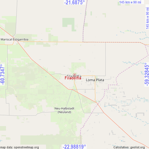
Filadelfia GPS coordinates[2]
22° 20' 21.696" South, 60° 1' 53.652" West
| Map corner | latitude | longitude |
|---|---|---|
| Upper-left | -21.6875°, | -60.7347° |
| Center: | -22.33936°, | -60.03157° |
| Lower-right: | -22.98819°, | -59.32845° |
| Map W x H: | 144.6×144.6 km | = 89.9×89.9mi |
| max Lat: | -19.91667° ⇑3.1% North |
| Filadelfia: | -22.33936° |
| min Lat: | ⇓96.9% South -27.38662° |
| min Long | Filadelfia | max Long |
| -60.78333° | -60.03157° | -54.30694° |
| W 1.2%⇐ | ⇒98.8% E |
Elevation
Elevation of Filadelfia is 140 m = 459 ft, and this is 29.7 m = 97 ft below average elevation for this country.
| Max E: |
658 m = 2159 ft | 50.6% |
| Avg. | 169.7 m = 557 ft | |
| Filadelfia | 140 m = 459 ft | |
Min E: |
46 m = 151 ft | 49.4% |
See also: Paraguay elevation on elevation.city.
Geographical zone
Filadelfia is located in South Torrid zone (between Equator and Tropic of Capricorn). Distance of this Southern Tropic circle is 122 km =75.8 mi to South.| Distance of | km | miles | from Filadelfia |
|---|---|---|---|
| Equator | 2483.9 | 1543.4 | to North |
| Tropic Capricorn | 122 | 75.8 | to South |
| Antarctic Circle | 4917.3 | 3055.5 | to South |
| South Pole | 7523.2 | 4674.7 | to South |


Nearby cities:
15 places around Filadelfia: (largest is in red/bold)
• Antequera
348.2 km =216.4 mi,  123°
123°
• Bella Vista
362.5 km =225.2 mi,  86°
86°
• Belén
310.1 km =192.7 mi,  113°
113°
• Capitán Pablo Lagerenza
280.4 km =174.2 mi,  343°
343°
• Colonia Menno
22.3 km =13.9 mi,  97°
97°
• Colonia Neuland
37.4 km =23.2 mi,  193°
193°
• Concepción
291.2 km =180.9 mi, 113°
• Fuerte Olimpo
265.6 km =165 mi,  57°
57°
• Horqueta
324.3 km =201.5 mi, 110°
• Puerto Rosario
376.2 km =233.8 mi,  128°
128°
• San Carlos
281.1 km =174.7 mi, 88°
• San Lázaro
218.5 km =135.8 mi,  84°
84°
• San Pablo de Ycuámandyyú
363.7 km =226 mi, 123°
• San Pedro de Ycuamandiyú
358 km =222.5 mi, 122°
• Tacuatí
374.2 km =232.5 mi, 109°
Sources, notices
• [Note1] Compared only with cities in Paraguay existing in our database
• [Src1] Map data: © OpenStreetMap contributors (CC-BY-SA)
• [Src2] Other city data from geonames.org with taken over terms of usage.
• [Src3] Geographical zone / Annual Mean Temperature by Robert A. Rohde @ Wikipedia
