Saint-Paul geodata
Saint-Paul (Réunion) is a populated place; located in Reunion in Indian/Reunion (GMT+4) time zone. With population of 99,307 people, there is 1 city with bigger population in this country. Compared to other cities in Reunion, 68.2% of cities are located further ↓South; 100% of cities are located further →East and 86.4% of cities have higher elevation than Saint-Paul. Note1
Administrative division(s):
- Level 1: Réunion
- Level 2: Réunion
- Level 3: Arrondissement de Saint-Paul
- Level 4: Saint-Paul


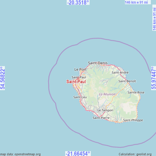
Saint-Paul GPS coordinates[2]
21° 0' 34.596" South, 55° 16' 16.824" East
| Map corner | latitude | longitude |
|---|---|---|
| Upper-left | -20.3518°, | 54.56822° |
| Center: | -21.00961°, | 55.27134° |
| Lower-right: | -21.66454°, | 55.97447° |
| Map W x H: | 146×146 km | = 90.7×90.7mi |
| max Lat: | -20.88231° ⇑31.8% North |
| Saint-Paul: | -21.00961° |
| min Lat: | ⇓68.2% South -21.3777° |
| min Long | Saint-Paul | max Long |
| 55.27134° | 55.27134° | 55.79616° |
| W 0%⇐ | ⇒100% E |
Elevation
Elevation of Saint-Paul is 12 m = 39 ft, and this is 178.8 m = 587 ft below average elevation for this country.
| Max E: |
887 m = 2910 ft | 86.4% |
| Avg. | 190.8 m = 626 ft | |
| Saint-Paul | 12 m = 39 ft | |
Min E: |
1 m = 3 ft | 13.6% |
See also: Saint-Paul elevation on elevation.city.
Geographical zone
Saint-Paul is located in South Torrid zone (between Equator and Tropic of Capricorn). Distance of this Southern Tropic circle is 269.9 km =167.7 mi to South.| Distance of | km | miles | from Saint-Paul |
|---|---|---|---|
| Equator | 2336 | 1451.5 | to North |
| Tropic Capricorn | 269.9 | 167.7 | to South |
| Antarctic Circle | 5065.1 | 3147.3 | to South |
| South Pole | 7671 | 4766.5 | to South |


Nearby cities:
15 places around Saint-Paul: (largest is in red/bold)
• Cilaos
25.1 km =15.6 mi,  124°
124°
• Entre-Deux
32.1 km =19.9 mi,  140°
140°
• La Possession
11.1 km =6.9 mi,  36°
36°
• Le Port
8.4 km =5.2 mi,  16°
16°
• Le Tampon
39.2 km =24.4 mi, 139°
• Les Avirons
26.6 km =16.5 mi,  165°
165°
• Les Trois-Bassins
10.5 km =6.5 mi,  163°
163°
• Piton Saint-Leu
23.8 km =14.8 mi, 168°
• Saint-André
39.7 km =24.7 mi,  82°
82°
• Saint-Denis
23.4 km =14.5 mi,  52°
52°
• Saint-Leu
18 km =11.2 mi, 174°
• Saint-Louis
34 km =21.1 mi,  154°
154°
• Sainte-Marie
31.6 km =19.6 mi,  66°
66°
• Sainte-Suzanne
36.8 km =22.9 mi, 71°
• Salazie
27.9 km =17.3 mi,  93°
93°
Sources, notices
• [Note1] Compared only with cities in Reunion existing in our database
• [Src1] Map data: © OpenStreetMap contributors (CC-BY-SA)
• [Src2] Other city data from geonames.org with taken over terms of usage.
• [Src3] Geographical zone / Annual Mean Temperature by Robert A. Rohde @ Wikipedia
