Saint-André geodata
Saint-André (Réunion) is a populated place; located in Reunion in Indian/Reunion (GMT+4) time zone. With population of 48,674 people, there are 4 cities with bigger population in this country. Compared to other cities in Reunion, 77.3% of cities are located further ↓South; 81.8% of cities are located further ←West and 54.5% of cities have lower elevation than Saint-André. Note1
Administrative division(s):
- Level 1: Réunion
- Level 2: Réunion
- Level 3: Arrondissement de Saint-Benoît
- Level 4: Saint-André


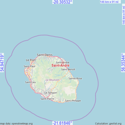
Saint-André GPS coordinates[2]
20° 57' 47.988" South, 55° 39' 1.116" East
| Map corner | latitude | longitude |
|---|---|---|
| Upper-left | -20.30532°, | 54.94719° |
| Center: | -20.96333°, | 55.65031° |
| Lower-right: | -21.61846°, | 56.35344° |
| Map W x H: | 146×146 km | = 90.7×90.7mi |
| max Lat: | -20.88231° ⇑22.7% North |
| Saint-André: | -20.96333° |
| min Lat: | ⇓77.3% South -21.3777° |
| min Long | Saint-André | max Long |
| 55.27134° | 55.65031° | 55.79616° |
| W 81.8%⇐ | ⇒18.2% E |
Elevation
Elevation of Saint-André is 103 m = 338 ft, and this is 87.8 m = 288 ft below average elevation for this country.
| Max E: |
887 m = 2910 ft | 45.5% |
| Avg. | 190.8 m = 626 ft | |
| Saint-André | 103 m = 338 ft | |
Min E: |
1 m = 3 ft | 54.5% |
See also: Saint-André elevation on elevation.city.
Geographical zone
Saint-André is located in South Torrid zone (between Equator and Tropic of Capricorn). Distance of this Southern Tropic circle is 275 km =170.9 mi to South.| Distance of | km | miles | from Saint-André |
|---|---|---|---|
| Equator | 2330.9 | 1448.4 | to North |
| Tropic Capricorn | 275 | 170.9 | to South |
| Antarctic Circle | 5070.3 | 3150.5 | to South |
| South Pole | 7676.2 | 4769.8 | to South |


Nearby cities:
15 places around Saint-André: (largest is in red/bold)
• Bras-Panon
4.7 km =2.9 mi,  141°
141°
• Cilaos
26.7 km =16.6 mi,  223°
223°
• Entre-Deux
35.6 km =22.1 mi,  212°
212°
• La Possession
33 km =20.5 mi,  276°
276°
• Le Port
37.1 km =23.1 mi,  274°
274°
• Le Tampon
37.5 km =23.3 mi,  201°
201°
• Les Trois-Bassins
39.4 km =24.5 mi,  247°
247°
• Saint-Benoît
10.7 km =6.6 mi, 140°
• Saint-Denis
22.6 km =14 mi,  293°
293°
• Saint-Louis
43.6 km =27.1 mi, 214°
• Saint-Paul
39.7 km =24.7 mi,  262°
262°
• Sainte-Marie
12.7 km =7.9 mi,  305°
305°
• Sainte-Rose
23.8 km =14.8 mi, 140°
• Sainte-Suzanne
7.7 km =4.8 mi,  325°
325°
• Salazie
13.5 km =8.4 mi,  238°
238°
Sources, notices
• [Note1] Compared only with cities in Reunion existing in our database
• [Src1] Map data: © OpenStreetMap contributors (CC-BY-SA)
• [Src2] Other city data from geonames.org with taken over terms of usage.
• [Src3] Geographical zone / Annual Mean Temperature by Robert A. Rohde @ Wikipedia
