Saint-Leu geodata
Saint-Leu (Réunion) is a populated place; located in Reunion in Indian/Reunion (GMT+4) time zone. With population of 28,278 people, there are 11 cities with bigger population in this country. Compared to other cities in Reunion, 59.1% of cities are located further ↑North; 95.5% of cities are located further →East and 90.9% of cities have higher elevation than Saint-Leu. Note1
Administrative division(s):
- Level 1: Réunion
- Level 2: Réunion
- Level 3: Arrondissement de Saint-Paul
- Level 4: Saint-Leu


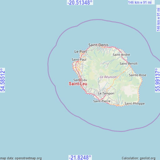
Saint-Leu GPS coordinates[2]
21° 10' 14.124" South, 55° 17' 17.664" East
| Map corner | latitude | longitude |
|---|---|---|
| Upper-left | -20.51348°, | 54.58512° |
| Center: | -21.17059°, | 55.28824° |
| Lower-right: | -21.8248°, | 55.99137° |
| Map W x H: | 145.8×145.8 km | = 90.6×90.6mi |
| max Lat: | -20.88231° ⇑59.1% North |
| Saint-Leu: | -21.17059° |
| min Lat: | ⇓40.9% South -21.3777° |
| min Long | Saint-Leu | max Long |
| 55.27134° | 55.28824° | 55.79616° |
| W 4.5%⇐ | ⇒95.5% E |
Elevation
Elevation of Saint-Leu is 10 m = 33 ft, and this is 180.8 m = 593 ft below average elevation for this country.
| Max E: |
887 m = 2910 ft | 90.9% |
| Avg. | 190.8 m = 626 ft | |
| Saint-Leu | 10 m = 33 ft | |
Min E: |
1 m = 3 ft | 9.1% |
See also: Reunion elevation on elevation.city.
Geographical zone
Saint-Leu is located in South Torrid zone (between Equator and Tropic of Capricorn). Distance of this Southern Tropic circle is 252 km =156.6 mi to South.| Distance of | km | miles | from Saint-Leu |
|---|---|---|---|
| Equator | 2353.9 | 1462.6 | to North |
| Tropic Capricorn | 252 | 156.6 | to South |
| Antarctic Circle | 5047.2 | 3136.2 | to South |
| South Pole | 7653.1 | 4755.4 | to South |


Nearby cities:
15 places around Saint-Leu: (largest is in red/bold)
• Cilaos
19.4 km =12.1 mi,  78°
78°
• Entre-Deux
19.8 km =12.3 mi,  110°
110°
• La Possession
27.3 km =17 mi,  10°
10°
• Le Port
25.9 km =16.1 mi,  1°
1°
• Le Tampon
26.5 km =16.5 mi,  116°
116°
• Les Avirons
9.3 km =5.8 mi,  147°
147°
• Les Trois-Bassins
7.9 km =4.9 mi, 8°
• Petite-Île
35.1 km =21.8 mi,  125°
125°
• Piton Saint-Leu
6.1 km =3.8 mi, 152°
• Saint-Denis
36.2 km =22.5 mi,  27°
27°
• Saint-Louis
18.1 km =11.2 mi,  135°
135°
• Saint-Paul
18 km =11.2 mi,  354°
354°
• Saint-Pierre
27.2 km =16.9 mi, 133°
• Sainte-Marie
40.8 km =25.4 mi,  41°
41°
• Salazie
30.6 km =19 mi,  58°
58°
Sources, notices
• [Note1] Compared only with cities in Reunion existing in our database
• [Src1] Map data: © OpenStreetMap contributors (CC-BY-SA)
• [Src2] Other city data from geonames.org with taken over terms of usage.
• [Src3] Geographical zone / Annual Mean Temperature by Robert A. Rohde @ Wikipedia
