Le Port geodata
Le Port (Réunion) is a populated place; located in Reunion in Indian/Reunion (GMT+4) time zone. With population of 40,771 people, there are 6 cities with bigger population in this country. Compared to other cities in Reunion, 81.8% of cities are located further ↓South; 90.9% of cities are located further →East and 100% of cities have higher elevation than Le Port. Note1
Administrative division(s):
- Level 1: Réunion
- Level 2: Réunion
- Level 3: Arrondissement de Saint-Paul
- Level 4: Le Port


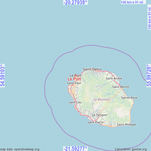
Le Port GPS coordinates[2]
20° 56' 15.072" South, 55° 17' 38.94" East
| Map corner | latitude | longitude |
|---|---|---|
| Upper-left | -20.27939°, | 54.59103° |
| Center: | -20.93752°, | 55.29415° |
| Lower-right: | -21.59277°, | 55.99728° |
| Map W x H: | 146×146 km | = 90.7×90.7mi |
| max Lat: | -20.88231° ⇑18.2% North |
| Le Port: | -20.93752° |
| min Lat: | ⇓81.8% South -21.3777° |
| min Long | Le Port | max Long |
| 55.27134° | 55.29415° | 55.79616° |
| W 9.1%⇐ | ⇒90.9% E |
Elevation
Elevation of Le Port is 1 m = 3 ft, and this is 189.8 m = 623 ft below average elevation for this country.
| Max E: |
887 m = 2910 ft | 100% |
| Avg. | 190.8 m = 626 ft | |
| Le Port | 1 m = 3 ft | |
Min E: |
1 m = 3 ft | 0% |
See also: Le Port elevation on elevation.city.
Geographical zone
Le Port is located in South Torrid zone (between Equator and Tropic of Capricorn). Distance of this Southern Tropic circle is 277.9 km =172.7 mi to South.| Distance of | km | miles | from Le Port |
|---|---|---|---|
| Equator | 2328 | 1446.6 | to North |
| Tropic Capricorn | 277.9 | 172.7 | to South |
| Antarctic Circle | 5073.1 | 3152.3 | to South |
| South Pole | 7679 | 4771.5 | to South |


Nearby cities:
15 places around Le Port: (largest is in red/bold)
• Bras-Panon
40.4 km =25.1 mi,  99°
99°
• Cilaos
28.8 km =17.9 mi,  140°
140°
• Entre-Deux
37.4 km =23.2 mi,  151°
151°
• La Possession
4.3 km =2.7 mi,  77°
77°
• Les Avirons
34 km =21.1 mi,  172°
172°
• Les Trois-Bassins
18.1 km =11.2 mi,  178°
178°
• Piton Saint-Leu
31.4 km =19.5 mi, 176°
• Saint-André
37.1 km =23.1 mi,  94°
94°
• Saint-Denis
17.4 km =10.8 mi,  69°
69°
• Saint-Leu
25.9 km =16.1 mi, 181°
• Saint-Louis
40.6 km =25.2 mi,  162°
162°
• Saint-Paul
8.4 km =5.2 mi,  196°
196°
• Sainte-Marie
27 km =16.8 mi, 80°
• Sainte-Suzanne
32.8 km =20.4 mi, 83°
• Salazie
27.3 km =17 mi,  111°
111°
Sources, notices
• [Note1] Compared only with cities in Reunion existing in our database
• [Src1] Map data: © OpenStreetMap contributors (CC-BY-SA)
• [Src2] Other city data from geonames.org with taken over terms of usage.
• [Src3] Geographical zone / Annual Mean Temperature by Robert A. Rohde @ Wikipedia
