Saint-Pierre geodata
Saint-Pierre (Réunion) is a populated place; located in Reunion in Indian/Reunion (GMT+4) time zone. With population of 76,655 people, there are 2 cities with bigger population in this country. Compared to other cities in Reunion, 86.4% of cities are located further ↑North; 50% of cities are located further ←West and 72.7% of cities have higher elevation than Saint-Pierre. Note1
Administrative division(s):
- Level 1: Réunion
- Level 2: Réunion
- Level 3: Arrondissement de Saint-Pierre
- Level 4: Saint-Pierre


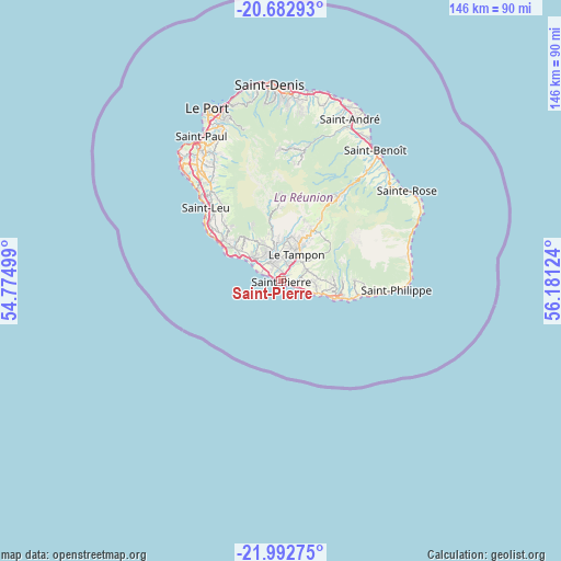
Saint-Pierre GPS coordinates[2]
21° 20' 21.48" South, 55° 28' 41.196" East
| Map corner | latitude | longitude |
|---|---|---|
| Upper-left | -20.68293°, | 54.77499° |
| Center: | -21.3393°, | 55.47811° |
| Lower-right: | -21.99275°, | 56.18124° |
| Map W x H: | 145.6×145.6 km | = 90.5×90.5mi |
| max Lat: | -20.88231° ⇑86.4% North |
| Saint-Pierre: | -21.3393° |
| min Lat: | ⇓13.6% South -21.3777° |
| min Long | Saint-Pierre | max Long |
| 55.27134° | 55.47811° | 55.79616° |
| W 50%⇐ | ⇒50% E |
Elevation
Elevation of Saint-Pierre is 36 m = 118 ft, and this is 154.8 m = 508 ft below average elevation for this country.
| Max E: |
887 m = 2910 ft | 72.7% |
| Avg. | 190.8 m = 626 ft | |
| Saint-Pierre | 36 m = 118 ft | |
Min E: |
1 m = 3 ft | 27.3% |
See also: Saint-Pierre elevation on elevation.city.
Geographical zone
Saint-Pierre is located in South Torrid zone (between Equator and Tropic of Capricorn). Distance of this Southern Tropic circle is 233.2 km =144.9 mi to South.| Distance of | km | miles | from Saint-Pierre |
|---|---|---|---|
| Equator | 2372.7 | 1474.3 | to North |
| Tropic Capricorn | 233.2 | 144.9 | to South |
| Antarctic Circle | 5028.5 | 3124.6 | to South |
| South Pole | 7634.4 | 4743.8 | to South |


Nearby cities:
15 places around Saint-Pierre: (largest is in red/bold)
• Cilaos
22.6 km =14 mi,  358°
358°
• Entre-Deux
11.8 km =7.3 mi,  354°
354°
• Le Tampon
8.1 km =5 mi,  30°
30°
• Les Avirons
18.3 km =11.4 mi,  306°
306°
• Les Trois-Bassins
32.4 km =20.1 mi,  325°
325°
• Petite-Île
9.1 km =5.7 mi,  99°
99°
• Piton Saint-Leu
21.5 km =13.4 mi, 308°
• Saint-Benoît
41.6 km =25.8 mi,  36°
36°
• Saint-Joseph
15 km =9.3 mi,  106°
106°
• Saint-Leu
27.2 km =16.9 mi, 313°
• Saint-Louis
9.1 km =5.7 mi, 310°
• Saint-Paul
42.5 km =26.4 mi, 329°
• Saint-Philippe
30.1 km =18.7 mi,  94°
94°
• Sainte-Rose
40.4 km =25.1 mi,  54°
54°
• Salazie
35.3 km =21.9 mi,  10°
10°
Sources, notices
• [Note1] Compared only with cities in Reunion existing in our database
• [Src1] Map data: © OpenStreetMap contributors (CC-BY-SA)
• [Src2] Other city data from geonames.org with taken over terms of usage.
• [Src3] Geographical zone / Annual Mean Temperature by Robert A. Rohde @ Wikipedia
