Sainte-Rose geodata
Sainte-Rose (Réunion) is a populated place; located in Reunion in Indian/Reunion (GMT+4) time zone. With population of 7,035 people, there are 19 cities with bigger population in this country. Compared to other cities in Reunion, 50% of cities are located further ↓South; 100% of cities are located further ←West and 72.7% of cities have lower elevation than Sainte-Rose. Note1
Administrative division(s):
- Level 1: Réunion
- Level 2: Réunion
- Level 3: Arrondissement de Saint-Benoît
- Level 4: Sainte-Rose


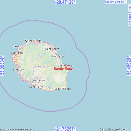
Sainte-Rose GPS coordinates[2]
21° 7' 42.888" South, 55° 47' 46.176" East
| Map corner | latitude | longitude |
|---|---|---|
| Upper-left | -20.47129°, | 55.09304° |
| Center: | -21.12858°, | 55.79616° |
| Lower-right: | -21.78297°, | 56.49929° |
| Map W x H: | 145.8×145.8 km | = 90.6×90.6mi |
| max Lat: | -20.88231° ⇑50% North |
| Sainte-Rose: | -21.12858° |
| min Lat: | ⇓50% South -21.3777° |
| min Long | Sainte-Rose | max Long |
| 55.27134° | 55.79616° | 55.79616° |
| W 100%⇐ | ⇒0% E |
Elevation
Elevation of Sainte-Rose is 184 m = 604 ft, and this is 6.8 m = 22 ft below average elevation for this country.
| Max E: |
887 m = 2910 ft | 27.3% |
| Avg. | 190.8 m = 626 ft | |
| Sainte-Rose | 184 m = 604 ft | |
Min E: |
1 m = 3 ft | 72.7% |
See also: Reunion elevation on elevation.city.
Geographical zone
Sainte-Rose is located in South Torrid zone (between Equator and Tropic of Capricorn). Distance of this Southern Tropic circle is 256.6 km =159.4 mi to South.| Distance of | km | miles | from Sainte-Rose |
|---|---|---|---|
| Equator | 2349.3 | 1459.8 | to North |
| Tropic Capricorn | 256.6 | 159.4 | to South |
| Antarctic Circle | 5051.9 | 3139.1 | to South |
| South Pole | 7657.8 | 4758.3 | to South |


Nearby cities:
15 places around Sainte-Rose: (largest is in red/bold)
• Bras-Panon
19.1 km =11.9 mi,  320°
320°
• Cilaos
33.6 km =20.9 mi,  268°
268°
• Entre-Deux
36.1 km =22.4 mi,  251°
251°
• Le Tampon
33.2 km =20.6 mi,  240°
240°
• Petite-Île
34.7 km =21.6 mi,  223°
223°
• Saint-André
23.8 km =14.8 mi, 320°
• Saint-Benoît
13.1 km =8.1 mi, 320°
• Saint-Denis
45.1 km =28 mi,  307°
307°
• Saint-Joseph
33.4 km =20.8 mi,  213°
213°
• Saint-Louis
43.6 km =27.1 mi, 246°
• Saint-Philippe
26 km =16.2 mi,  186°
186°
• Saint-Pierre
40.4 km =25.1 mi,  234°
234°
• Sainte-Marie
36.2 km =22.5 mi, 315°
• Sainte-Suzanne
31.5 km =19.6 mi, 321°
• Salazie
28.9 km =18 mi,  292°
292°
Sources, notices
• [Note1] Compared only with cities in Reunion existing in our database
• [Src1] Map data: © OpenStreetMap contributors (CC-BY-SA)
• [Src2] Other city data from geonames.org with taken over terms of usage.
• [Src3] Geographical zone / Annual Mean Temperature by Robert A. Rohde @ Wikipedia
