Saint-Benoît geodata
Saint-Benoît (Réunion) is a populated place; located in Reunion in Indian/Reunion (GMT+4) time zone. With population of 35,310 people, there are 7 cities with bigger population in this country. Compared to other cities in Reunion, 59.1% of cities are located further ↓South; 90.9% of cities are located further ←West and 50% of cities have lower elevation than Saint-Benoît. Note1
Administrative division(s):
- Level 1: Réunion
- Level 2: Réunion
- Level 3: Arrondissement de Saint-Benoît
- Level 4: Saint-Benoît


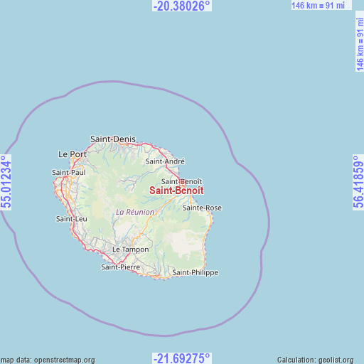
Saint-Benoît GPS coordinates[2]
21° 2' 16.62" South, 55° 42' 55.656" East
| Map corner | latitude | longitude |
|---|---|---|
| Upper-left | -20.38026°, | 55.01234° |
| Center: | -21.03795°, | 55.71546° |
| Lower-right: | -21.69275°, | 56.41859° |
| Map W x H: | 145.9×145.9 km | = 90.7×90.7mi |
| max Lat: | -20.88231° ⇑40.9% North |
| Saint-Benoît: | -21.03795° |
| min Lat: | ⇓59.1% South -21.3777° |
| min Long | Saint-Benoît | max Long |
| 55.27134° | 55.71546° | 55.79616° |
| W 90.9%⇐ | ⇒9.1% E |
Elevation
Elevation of Saint-Benoît is 78 m = 256 ft, and this is 112.8 m = 370 ft below average elevation for this country.
| Max E: |
887 m = 2910 ft | 50% |
| Avg. | 190.8 m = 626 ft | |
| Saint-Benoît | 78 m = 256 ft | |
Min E: |
1 m = 3 ft | 50% |
See also: Reunion elevation on elevation.city.
Geographical zone
Saint-Benoît is located in South Torrid zone (between Equator and Tropic of Capricorn). Distance of this Southern Tropic circle is 266.7 km =165.7 mi to South.| Distance of | km | miles | from Saint-Benoît |
|---|---|---|---|
| Equator | 2339.2 | 1453.5 | to North |
| Tropic Capricorn | 266.7 | 165.7 | to South |
| Antarctic Circle | 5062 | 3145.4 | to South |
| South Pole | 7667.9 | 4764.6 | to South |


Nearby cities:
15 places around Saint-Benoît: (largest is in red/bold)
• Bras-Panon
6 km =3.7 mi,  319°
319°
• Cilaos
27.5 km =17.1 mi,  246°
246°
• Entre-Deux
33.7 km =20.9 mi,  229°
229°
• La Possession
41.3 km =25.7 mi,  287°
287°
• Le Tampon
33.5 km =20.8 mi,  217°
217°
• Petite-Île
38.4 km =23.9 mi,  204°
204°
• Saint-André
10.7 km =6.6 mi, 320°
• Saint-Denis
32.5 km =20.2 mi,  302°
302°
• Saint-Joseph
39.1 km =24.3 mi, 195°
• Saint-Philippe
36.3 km =22.6 mi,  171°
171°
• Saint-Pierre
41.6 km =25.8 mi, 216°
• Sainte-Marie
23.2 km =14.4 mi,  312°
312°
• Sainte-Rose
13.1 km =8.1 mi,  140°
140°
• Sainte-Suzanne
18.4 km =11.4 mi, 322°
• Salazie
18.3 km =11.4 mi,  273°
273°
Sources, notices
• [Note1] Compared only with cities in Reunion existing in our database
• [Src1] Map data: © OpenStreetMap contributors (CC-BY-SA)
• [Src2] Other city data from geonames.org with taken over terms of usage.
• [Src3] Geographical zone / Annual Mean Temperature by Robert A. Rohde @ Wikipedia
