Boureni geodata
Boureni (Iaşi) is a populated place; located in Romania in Europe/Bucharest (GMT+3) time zone. With population of 1,390 people, there are 3356 cities with bigger population in this country. Compared to other cities in Romania, 84.3% of cities are located further ↓South; 75.1% of cities are located further ←West and 64.2% of cities have lower elevation than Boureni. Note1


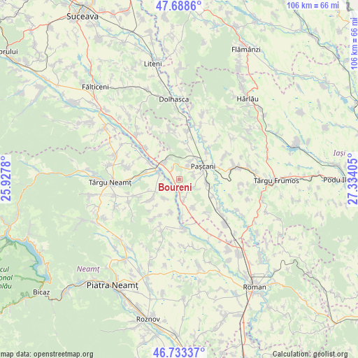
Boureni GPS coordinates[2]
47° 12' 47.304" North, 26° 37' 51.312" East
| Map corner | latitude | longitude |
|---|---|---|
| Upper-left | 47.6886°, | 25.9278° |
| Center: | 47.21314°, | 26.63092° |
| Lower-right: | 46.73337°, | 27.33405° |
| Map W x H: | 106.2×106.2 km | = 66×66mi |
| max Lat: | 48.23793° ⇑15.7% North |
| Boureni: | 47.21314° |
| min Lat: | ⇓84.3% South 43.65638° |
| min Long | Boureni | max Long |
| 20.31667° | 26.63092° | 29.65403° |
| W 75.1%⇐ | ⇒24.9% E |
Elevation
Elevation of Boureni is 285 m = 935 ft, and this is 30.1 m = 99 ft above average elevation for this country.
| Max E: |
1278 m = 4193 ft | 35.8% |
| Boureni | 285 m 935 ft | |
| Avg. | 254.9 m = 836 ft | |
Min E: |
-2 m = -7 ft | 64.2% |
See also: Romania elevation on elevation.city.
Geographical zone
Boureni is located in North temperate zone (between Tropic of Cancer and the Arctic Circle). Distance of this North polar circle is 2151.6 km =1336.9 mi to North.| Distance of | km | miles | from Boureni |
|---|---|---|---|
| North Pole | 4757.5 | 2956.2 | to North |
| Arctic Circle | 2151.6 | 1336.9 | to North |
| Tropic Cancer | 2643.7 | 1642.7 | to South |
| Equator | 5249.6 | 3261.9 | to South |


Nearby cities:
15 places around Boureni: (largest is in red/bold)
• Brătești
4.8 km =3 mi,  120°
120°
• Ciohorăni
9.7 km =6 mi,  152°
152°
• Cristeşti
7.7 km =4.8 mi,  320°
320°
• Davideni
9.9 km =6.2 mi,  193°
193°
• Ingărești
8 km =5 mi,  241°
241°
• Miroslovești
7.2 km =4.5 mi,  168°
168°
• Moţca
4.2 km =2.6 mi,  345°
345°
• Paşcani
7.9 km =4.9 mi,  61°
61°
• Păstrăveni
7.1 km =4.4 mi,  223°
223°
• Soci
3.2 km =2 mi,  161°
161°
• Sodomeni
4.4 km =2.7 mi,  76°
76°
• Stolniceni-Prăjescu
9 km =5.6 mi,  100°
100°
• Timişeşti
6.5 km =4 mi,  290°
290°
• Topile
6.3 km =3.9 mi,  27°
27°
• Valea Seacă
9.2 km =5.7 mi,  17°
17°
Sources, notices
• [Note1] Compared only with cities in Romania existing in our database
• [Src1] Map data: © OpenStreetMap contributors (CC-BY-SA)
• [Src2] Other city data from geonames.org with taken over terms of usage.
• [Src3] Geographical zone / Annual Mean Temperature by Robert A. Rohde @ Wikipedia
