Sighișoara geodata
Sighișoara (Mureş) is a seat of a second-order administrative division; located in Romania in Europe/Bucharest (GMT+3) time zone. With population of 34,537 people, there are 63 cities with bigger population in this country. Compared to other cities in Romania, 60.1% of cities are located further ↓South; 55.6% of cities are located further →East and 75.6% of cities have lower elevation than Sighișoara. Note1


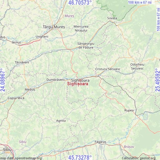
Sighișoara GPS coordinates[2]
46° 13' 17.076" North, 24° 47' 34.044" East
| Map corner | latitude | longitude |
|---|---|---|
| Upper-left | 46.70573°, | 24.08967° |
| Center: | 46.22141°, | 24.79279° |
| Lower-right: | 45.73278°, | 25.49592° |
| Map W x H: | 108.2×108.2 km | = 67.2×67.2mi |
| max Lat: | 48.23793° ⇑39.9% North |
| Sighișoara: | 46.22141° |
| min Lat: | ⇓60.1% South 43.65638° |
| min Long | Sighișoara | max Long |
| 20.31667° | 24.79279° | 29.65403° |
| W 44.4%⇐ | ⇒55.6% E |
Elevation
Elevation of Sighișoara is 358 m = 1175 ft, and this is 103.1 m = 338 ft above average elevation for this country.
| Max E: |
1278 m = 4193 ft | 24.4% |
| Sighișoara | 358 m 1175 ft | |
| Avg. | 254.9 m = 836 ft | |
Min E: |
-2 m = -7 ft | 75.6% |
See also: Romania elevation on elevation.city.
Geographical zone
Sighișoara is located in North temperate zone (between Tropic of Cancer and the Arctic Circle). Distance of this North polar circle is 2261.8 km =1405.4 mi to North.| Distance of | km | miles | from Sighișoara |
|---|---|---|---|
| North Pole | 4867.7 | 3024.6 | to North |
| Arctic Circle | 2261.8 | 1405.4 | to North |
| Tropic Cancer | 2533.4 | 1574.2 | to South |
| Equator | 5139.3 | 3193.4 | to South |


Nearby cities:
15 places around Sighișoara: (largest is in red/bold)
• Albeşti
4.6 km =2.9 mi,  73°
73°
• Apold
11.8 km =7.3 mi,  171°
171°
• Boiu
7.9 km =4.9 mi,  50°
50°
• Criș
11.5 km =7.1 mi,  221°
221°
• Daia
11.8 km =7.3 mi,  134°
134°
• Daneş
7.2 km =4.5 mi,  265°
265°
• Eliseni
13.6 km =8.5 mi, 54°
• Hetiur
5.8 km =3.6 mi,  343°
343°
• Hoghilag
13.6 km =8.5 mi,  275°
275°
• Laslea
11 km =6.8 mi, 267°
• Nadeş
11.5 km =7.1 mi, 336°
• Seleuș
7.9 km =4.9 mi,  287°
287°
• Vânători
10.9 km =6.8 mi,  83°
83°
• Șaeș
7.5 km =4.7 mi,  194°
194°
• Șoard
11.3 km =7 mi, 65°
Sources, notices
• [Note1] Compared only with cities in Romania existing in our database
• [Src1] Map data: © OpenStreetMap contributors (CC-BY-SA)
• [Src2] Other city data from geonames.org with taken over terms of usage.
• [Src3] Geographical zone / Annual Mean Temperature by Robert A. Rohde @ Wikipedia
