Hetiur geodata
Hetiur (Mureş) is a populated place; located in Romania in Europe/Bucharest (GMT+3) time zone. With population of 865 people, there are 4774 cities with bigger population in this country. Compared to other cities in Romania, 61.4% of cities are located further ↓South; 56% of cities are located further →East and 81.3% of cities have lower elevation than Hetiur. Note1


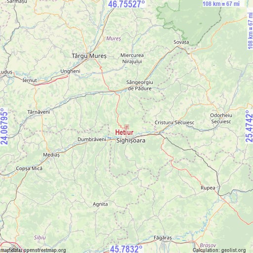
Hetiur GPS coordinates[2]
46° 16' 17.004" North, 24° 46' 15.852" East
| Map corner | latitude | longitude |
|---|---|---|
| Upper-left | 46.75527°, | 24.06795° |
| Center: | 46.27139°, | 24.77107° |
| Lower-right: | 45.7832°, | 25.4742° |
| Map W x H: | 108.1×108.1 km | = 67.2×67.2mi |
| max Lat: | 48.23793° ⇑38.6% North |
| Hetiur: | 46.27139° |
| min Lat: | ⇓61.4% South 43.65638° |
| min Long | Hetiur | max Long |
| 20.31667° | 24.77107° | 29.65403° |
| W 44%⇐ | ⇒56% E |
Elevation
Elevation of Hetiur is 405 m = 1329 ft, and this is 150.1 m = 492 ft above average elevation for this country.
| Max E: |
1278 m = 4193 ft | 18.7% |
| Hetiur | 405 m 1329 ft | |
| Avg. | 254.9 m = 836 ft | |
Min E: |
-2 m = -7 ft | 81.3% |
See also: Romania elevation on elevation.city.
Geographical zone
Hetiur is located in North temperate zone (between Tropic of Cancer and the Arctic Circle). Distance of this North polar circle is 2256.3 km =1402 mi to North.| Distance of | km | miles | from Hetiur |
|---|---|---|---|
| North Pole | 4862.2 | 3021.2 | to North |
| Arctic Circle | 2256.3 | 1402 | to North |
| Tropic Cancer | 2539 | 1577.7 | to South |
| Equator | 5144.9 | 3196.9 | to South |


Nearby cities:
15 places around Hetiur: (largest is in red/bold)
• Albeşti
7.4 km =4.6 mi,  124°
124°
• Boiu
7.8 km =4.8 mi,  94°
94°
• Daneş
8.2 km =5.1 mi,  221°
221°
• Eliseni
13 km =8.1 mi,  79°
79°
• Hoghilag
12.6 km =7.8 mi,  250°
250°
• Laslea
11.1 km =6.9 mi,  236°
236°
• Nadeş
5.8 km =3.6 mi,  330°
330°
• Seleuș
6.7 km =4.2 mi, 241°
• Senereuș
11.6 km =7.2 mi,  307°
307°
• Sighișoara
5.8 km =3.6 mi,  163°
163°
• Săcel
12.9 km =8 mi, 75°
• Veţca
8.8 km =5.5 mi,  6°
6°
• Șaeș
12.8 km =8 mi,  180°
180°
• Șoard
12 km =7.5 mi, 94°
• Țigmandru
10.2 km =6.3 mi,  336°
336°
Sources, notices
• [Note1] Compared only with cities in Romania existing in our database
• [Src1] Map data: © OpenStreetMap contributors (CC-BY-SA)
• [Src2] Other city data from geonames.org with taken over terms of usage.
• [Src3] Geographical zone / Annual Mean Temperature by Robert A. Rohde @ Wikipedia
