Sâniob geodata
Sâniob (Bihor) is a seat of a second-order administrative division; located in Romania in Europe/Bucharest (GMT+3) time zone. With population of 1,391 people, there are 3352 cities with bigger population in this country. Compared to other cities in Romania, 85.8% of cities are located further ↓South; 93.3% of cities are located further →East and 70.9% of cities have higher elevation than Sâniob. Note1


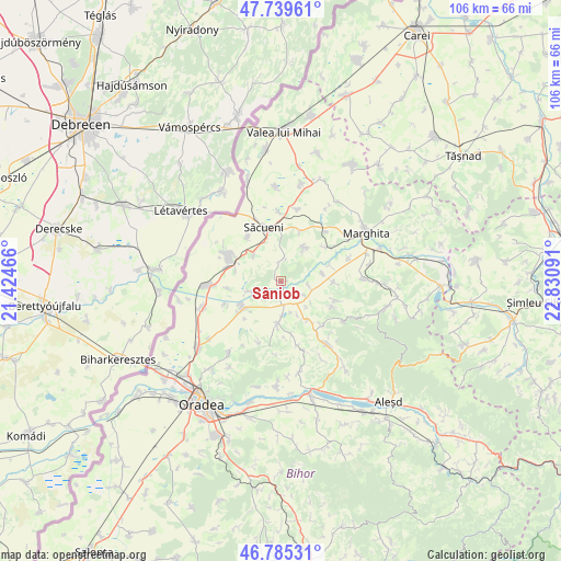
Sâniob GPS coordinates[2]
47° 15' 52.596" North, 22° 7' 40.008" East
| Map corner | latitude | longitude |
|---|---|---|
| Upper-left | 47.73961°, | 21.42466° |
| Center: | 47.26461°, | 22.12778° |
| Lower-right: | 46.78531°, | 22.83091° |
| Map W x H: | 106.1×106.1 km | = 65.9×65.9mi |
| max Lat: | 48.23793° ⇑14.2% North |
| Sâniob: | 47.26461° |
| min Lat: | ⇓85.8% South 43.65638° |
| min Long | Sâniob | max Long |
| 20.31667° | 22.12778° | 29.65403° |
| W 6.7%⇐ | ⇒93.3% E |
Elevation
Elevation of Sâniob is 124 m = 407 ft, and this is 130.9 m = 429 ft below average elevation for this country.
| Max E: |
1278 m = 4193 ft | 70.9% |
| Avg. | 254.9 m = 836 ft | |
| Sâniob | 124 m = 407 ft | |
Min E: |
-2 m = -7 ft | 29.1% |
See also: Romania elevation on elevation.city.
Geographical zone
Sâniob is located in North temperate zone (between Tropic of Cancer and the Arctic Circle). Distance of this North polar circle is 2145.8 km =1333.3 mi to North.| Distance of | km | miles | from Sâniob |
|---|---|---|---|
| North Pole | 4751.7 | 2952.6 | to North |
| Arctic Circle | 2145.8 | 1333.3 | to North |
| Tropic Cancer | 2649.4 | 1646.3 | to South |
| Equator | 5255.3 | 3265.5 | to South |


Nearby cities:
15 places around Sâniob: (largest is in red/bold)
• Cadea
7.2 km =4.5 mi,  316°
316°
• Chişlaz
8.2 km =5.1 mi,  75°
75°
• Ciocaia
10.3 km =6.4 mi, 323°
• Cubulcut
7.8 km =4.8 mi,  34°
34°
• Dernișoara
10.6 km =6.6 mi,  117°
117°
• Diosig
10.4 km =6.5 mi,  292°
292°
• Mișca
9.9 km =6.2 mi,  91°
91°
• Olosig
10.4 km =6.5 mi,  21°
21°
• Spinuş
9 km =5.6 mi,  142°
142°
• Sânnicolau de Munte
4.4 km =2.7 mi,  8°
8°
• Sântimreu
6.5 km =4 mi,  254°
254°
• Sârbi
8 km =5 mi,  183°
183°
• Săcueni
9.7 km =6 mi,  347°
347°
• Sălard
7.9 km =4.9 mi,  227°
227°
• Vaida
10.1 km =6.3 mi,  262°
262°
Sources, notices
• [Note1] Compared only with cities in Romania existing in our database
• [Src1] Map data: © OpenStreetMap contributors (CC-BY-SA)
• [Src2] Other city data from geonames.org with taken over terms of usage.
• [Src3] Geographical zone / Annual Mean Temperature by Robert A. Rohde @ Wikipedia
