Cubulcut geodata
Cubulcut (Bihor) is a populated place; located in Romania in Europe/Bucharest (GMT+3) time zone. With population of 1,062 people, there are 4080 cities with bigger population in this country. Compared to other cities in Romania, 87.2% of cities are located further ↓South; 92.8% of cities are located further →East and 56.8% of cities have higher elevation than Cubulcut. Note1


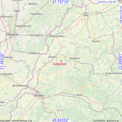
Cubulcut GPS coordinates[2]
47° 19' 21.72" North, 22° 11' 11.328" East
| Map corner | latitude | longitude |
|---|---|---|
| Upper-left | 47.79718°, | 21.48336° |
| Center: | 47.3227°, | 22.18648° |
| Lower-right: | 46.84392°, | 22.88961° |
| Map W x H: | 106×106 km | = 65.9×65.9mi |
| max Lat: | 48.23793° ⇑12.8% North |
| Cubulcut: | 47.3227° |
| min Lat: | ⇓87.2% South 43.65638° |
| min Long | Cubulcut | max Long |
| 20.31667° | 22.18648° | 29.65403° |
| W 7.2%⇐ | ⇒92.8% E |
Elevation
Elevation of Cubulcut is 179 m = 587 ft, and this is 75.9 m = 249 ft below average elevation for this country.
| Max E: |
1278 m = 4193 ft | 56.8% |
| Avg. | 254.9 m = 836 ft | |
| Cubulcut | 179 m = 587 ft | |
Min E: |
-2 m = -7 ft | 43.2% |
See also: Romania elevation on elevation.city.
Geographical zone
Cubulcut is located in North temperate zone (between Tropic of Cancer and the Arctic Circle). Distance of this North polar circle is 2139.4 km =1329.4 mi to North.| Distance of | km | miles | from Cubulcut |
|---|---|---|---|
| North Pole | 4745.3 | 2948.6 | to North |
| Arctic Circle | 2139.4 | 1329.4 | to North |
| Tropic Cancer | 2655.9 | 1650.3 | to South |
| Equator | 5261.8 | 3269.5 | to South |


Nearby cities:
15 places around Cubulcut: (largest is in red/bold)
• Abrămuţ
4.8 km =3 mi,  97°
97°
• Albiș
8.7 km =5.4 mi,  30°
30°
• Buduslău
10.5 km =6.5 mi,  35°
35°
• Cadea
9.4 km =5.8 mi,  262°
262°
• Cherechiu
7.8 km =4.8 mi,  329°
329°
• Chiraleu
8.7 km =5.4 mi, 102°
• Chişlaz
5.6 km =3.5 mi,  141°
141°
• Ciocaia
10.8 km =6.7 mi,  279°
279°
• Mișca
8.6 km =5.3 mi, 140°
• Olosig
3.3 km =2.1 mi,  349°
349°
• Petreu
8.4 km =5.2 mi,  78°
78°
• Sâniob
7.8 km =4.8 mi,  214°
214°
• Sânnicolau de Munte
4.3 km =2.7 mi,  240°
240°
• Săcueni
7.2 km =4.5 mi,  294°
294°
• Târgușor
6.9 km =4.3 mi, 347°
Sources, notices
• [Note1] Compared only with cities in Romania existing in our database
• [Src1] Map data: © OpenStreetMap contributors (CC-BY-SA)
• [Src2] Other city data from geonames.org with taken over terms of usage.
• [Src3] Geographical zone / Annual Mean Temperature by Robert A. Rohde @ Wikipedia
