Olosig geodata
Olosig (Bihor) is a populated place; located in Romania in Europe/Bucharest (GMT+3) time zone. With population of 574 people, there are 6394 cities with bigger population in this country. Compared to other cities in Romania, 87.9% of cities are located further ↓South; 92.9% of cities are located further →East and 65.7% of cities have higher elevation than Olosig. Note1


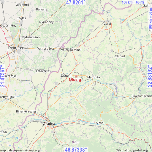
Olosig GPS coordinates[2]
47° 21' 6.804" North, 22° 10' 43.644" East
| Map corner | latitude | longitude |
|---|---|---|
| Upper-left | 47.8261°, | 21.47567° |
| Center: | 47.35189°, | 22.17879° |
| Lower-right: | 46.87338°, | 22.88192° |
| Map W x H: | 105.9×105.9 km | = 65.8×65.8mi |
| max Lat: | 48.23793° ⇑12.1% North |
| Olosig: | 47.35189° |
| min Lat: | ⇓87.9% South 43.65638° |
| min Long | Olosig | max Long |
| 20.31667° | 22.17879° | 29.65403° |
| W 7.1%⇐ | ⇒92.9% E |
Elevation
Elevation of Olosig is 144 m = 472 ft, and this is 110.9 m = 364 ft below average elevation for this country.
| Max E: |
1278 m = 4193 ft | 65.7% |
| Avg. | 254.9 m = 836 ft | |
| Olosig | 144 m = 472 ft | |
Min E: |
-2 m = -7 ft | 34.3% |
See also: Romania elevation on elevation.city.
Geographical zone
Olosig is located in North temperate zone (between Tropic of Cancer and the Arctic Circle). Distance of this North polar circle is 2136.1 km =1327.3 mi to North.| Distance of | km | miles | from Olosig |
|---|---|---|---|
| North Pole | 4742 | 2946.5 | to North |
| Arctic Circle | 2136.1 | 1327.3 | to North |
| Tropic Cancer | 2659.1 | 1652.3 | to South |
| Equator | 5265 | 3271.5 | to South |


Nearby cities:
15 places around Olosig: (largest is in red/bold)
• Abrămuţ
6.6 km =4.1 mi,  126°
126°
• Adoni
9 km =5.6 mi,  358°
358°
• Albiș
6.6 km =4.1 mi,  49°
49°
• Buduslău
8.5 km =5.3 mi, 51°
• Cadea
9.8 km =6.1 mi,  243°
243°
• Cherechiu
4.9 km =3 mi,  315°
315°
• Cheșereu
9.7 km =6 mi,  330°
330°
• Chiraleu
10.4 km =6.5 mi,  119°
119°
• Chişlaz
8.7 km =5.4 mi,  151°
151°
• Ciocaia
10.1 km =6.3 mi,  261°
261°
• Cubulcut
3.3 km =2.1 mi,  169°
169°
• Petreu
9 km =5.6 mi,  100°
100°
• Sânnicolau de Munte
6.2 km =3.9 mi,  210°
210°
• Săcueni
5.9 km =3.7 mi,  267°
267°
• Târgușor
3.6 km =2.2 mi,  345°
345°
Sources, notices
• [Note1] Compared only with cities in Romania existing in our database
• [Src1] Map data: © OpenStreetMap contributors (CC-BY-SA)
• [Src2] Other city data from geonames.org with taken over terms of usage.
• [Src3] Geographical zone / Annual Mean Temperature by Robert A. Rohde @ Wikipedia
