Brăteni geodata
Brăteni (Botoşani) is a populated place; located in Romania in Europe/Bucharest (GMT+3) time zone. With population of 725 people, there are 5434 cities with bigger population in this country. Compared to other cities in Romania, 97.5% of cities are located further ↓South; 83.3% of cities are located further ←West and 51.5% of cities have higher elevation than Brăteni. Note1


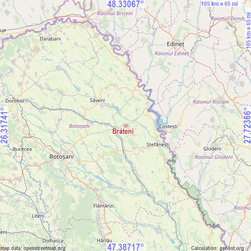
Brăteni GPS coordinates[2]
47° 51' 39.852" North, 27° 1' 13.908" East
| Map corner | latitude | longitude |
|---|---|---|
| Upper-left | 48.33067°, | 26.31741° |
| Center: | 47.86107°, | 27.02053° |
| Lower-right: | 47.38717°, | 27.72366° |
| Map W x H: | 104.9×104.9 km | = 65.2×65.2mi |
| max Lat: | 48.23793° ⇑2.5% North |
| Brăteni: | 47.86107° |
| min Lat: | ⇓97.5% South 43.65638° |
| min Long | Brăteni | max Long |
| 20.31667° | 27.02053° | 29.65403° |
| W 83.3%⇐ | ⇒16.7% E |
Elevation
Elevation of Brăteni is 204 m = 669 ft, and this is 50.9 m = 167 ft below average elevation for this country.
| Max E: |
1278 m = 4193 ft | 51.5% |
| Avg. | 254.9 m = 836 ft | |
| Brăteni | 204 m = 669 ft | |
Min E: |
-2 m = -7 ft | 48.5% |
See also: Romania elevation on elevation.city.
Geographical zone
Brăteni is located in North temperate zone (between Tropic of Cancer and the Arctic Circle). Distance of this North polar circle is 2079.5 km =1292.1 mi to North.| Distance of | km | miles | from Brăteni |
|---|---|---|---|
| North Pole | 4685.4 | 2911.4 | to North |
| Arctic Circle | 2079.5 | 1292.1 | to North |
| Tropic Cancer | 2715.7 | 1687.5 | to South |
| Equator | 5321.7 | 3306.8 | to South |


Nearby cities:
15 places around Brăteni: (largest is in red/bold)
• Buhăceni
5.6 km =3.5 mi,  196°
196°
• Băbiceni
12.5 km =7.8 mi,  161°
161°
• Dobârceni
6 km =3.7 mi,  145°
145°
• Drislea
10.6 km =6.6 mi, 199°
• Durneşti
12.1 km =7.5 mi, 150°
• Dângeni
4.2 km =2.6 mi,  252°
252°
• Guranda
10 km =6.2 mi, 159°
• Hulub
5.7 km =3.5 mi,  226°
226°
• Hăneşti
6.8 km =4.2 mi,  335°
335°
• Iacobeni
8 km =5 mi,  270°
270°
• Mihălăşeni
4.2 km =2.6 mi,  54°
54°
• Socrujeni
11.9 km =7.4 mi,  222°
222°
• Sârbi
11.9 km =7.4 mi,  319°
319°
• Truşeşti
10.5 km =6.5 mi,  181°
181°
• Zahoreni
11.4 km =7.1 mi,  11°
11°
Sources, notices
• [Note1] Compared only with cities in Romania existing in our database
• [Src1] Map data: © OpenStreetMap contributors (CC-BY-SA)
• [Src2] Other city data from geonames.org with taken over terms of usage.
• [Src3] Geographical zone / Annual Mean Temperature by Robert A. Rohde @ Wikipedia
