Mihălăşeni geodata
Mihălăşeni (Botoşani) is a seat of a second-order administrative division; located in Romania in Europe/Bucharest (GMT+3) time zone. With population of 2,438 people, there are 2211 cities with bigger population in this country. Compared to other cities in Romania, 97.7% of cities are located further ↓South; 84.2% of cities are located further ←West and 81.4% of cities have higher elevation than Mihălăşeni. Note1


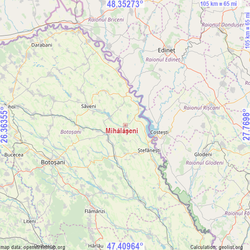
Mihălăşeni GPS coordinates[2]
47° 52' 59.988" North, 27° 4' 0.012" East
| Map corner | latitude | longitude |
|---|---|---|
| Upper-left | 48.35273°, | 26.36355° |
| Center: | 47.88333°, | 27.06667° |
| Lower-right: | 47.40964°, | 27.7698° |
| Map W x H: | 104.9×104.9 km | = 65.2×65.2mi |
| max Lat: | 48.23793° ⇑2.3% North |
| Mihălăşeni: | 47.88333° |
| min Lat: | ⇓97.7% South 43.65638° |
| min Long | Mihălăşeni | max Long |
| 20.31667° | 27.06667° | 29.65403° |
| W 84.2%⇐ | ⇒15.8% E |
Elevation
Elevation of Mihălăşeni is 90 m = 295 ft, and this is 164.9 m = 541 ft below average elevation for this country.
| Max E: |
1278 m = 4193 ft | 81.4% |
| Avg. | 254.9 m = 836 ft | |
| Mihălăşeni | 90 m = 295 ft | |
Min E: |
-2 m = -7 ft | 18.6% |
See also: Romania elevation on elevation.city.
Geographical zone
Mihălăşeni is located in North temperate zone (between Tropic of Cancer and the Arctic Circle). Distance of this North polar circle is 2077 km =1290.6 mi to North.| Distance of | km | miles | from Mihălăşeni |
|---|---|---|---|
| North Pole | 4682.9 | 2909.8 | to North |
| Arctic Circle | 2077 | 1290.6 | to North |
| Tropic Cancer | 2718.2 | 1689 | to South |
| Equator | 5324.1 | 3308.2 | to South |


Nearby cities:
15 places around Mihălăşeni: (largest is in red/bold)
• Brăteni
4.2 km =2.6 mi,  234°
234°
• Buhăceni
9.3 km =5.8 mi,  212°
212°
• Cucuteni
12.7 km =7.9 mi,  155°
155°
• Dobârceni
7.4 km =4.6 mi,  180°
180°
• Dângeni
8.3 km =5.2 mi,  243°
243°
• Guranda
11.8 km =7.3 mi, 179°
• Hulub
9.9 km =6.2 mi, 229°
• Hăneşti
7.2 km =4.5 mi,  300°
300°
• Iacobeni
11.7 km =7.3 mi,  257°
257°
• Manoleasa
11.1 km =6.9 mi,  0°
0°
• Ripiceni
8.9 km =5.5 mi,  33°
33°
• Sadoveni
12.6 km =7.8 mi,  23°
23°
• Stânca
12.4 km =7.7 mi,  122°
122°
• Tudor Vladimirescu
12.5 km =7.8 mi,  335°
335°
• Zahoreni
8.8 km =5.5 mi,  351°
351°
Sources, notices
• [Note1] Compared only with cities in Romania existing in our database
• [Src1] Map data: © OpenStreetMap contributors (CC-BY-SA)
• [Src2] Other city data from geonames.org with taken over terms of usage.
• [Src3] Geographical zone / Annual Mean Temperature by Robert A. Rohde @ Wikipedia
