Vlașin geodata
Vlașin (Giurgiu) is a populated place; located in Romania in Europe/Bucharest (GMT+3) time zone. With population of 572 people, there are 6412 cities with bigger population in this country. Compared to other cities in Romania, 95.4% of cities are located further ↑North; 60.4% of cities are located further ←West and 83.1% of cities have higher elevation than Vlașin. Note1


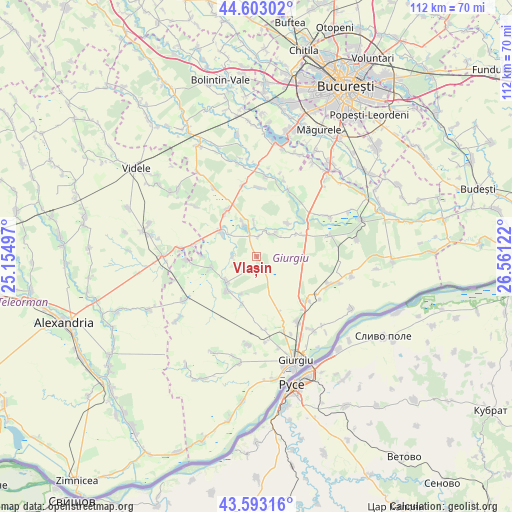
Vlașin GPS coordinates[2]
44° 6' 0.9" North, 25° 51' 29.124" East
| Map corner | latitude | longitude |
|---|---|---|
| Upper-left | 44.60302°, | 25.15497° |
| Center: | 44.10025°, | 25.85809° |
| Lower-right: | 43.59316°, | 26.56122° |
| Map W x H: | 112.3×112.3 km | = 69.8×69.8mi |
| max Lat: | 48.23793° ⇑95.4% North |
| Vlașin: | 44.10025° |
| min Lat: | ⇓4.6% South 43.65638° |
| min Long | Vlașin | max Long |
| 20.31667° | 25.85809° | 29.65403° |
| W 60.4%⇐ | ⇒39.6% E |
Elevation
Elevation of Vlașin is 84 m = 276 ft, and this is 170.9 m = 561 ft below average elevation for this country.
| Max E: |
1278 m = 4193 ft | 83.1% |
| Avg. | 254.9 m = 836 ft | |
| Vlașin | 84 m = 276 ft | |
Min E: |
-2 m = -7 ft | 16.9% |
See also: Romania elevation on elevation.city.
Geographical zone
Vlașin is located in North temperate zone (between Tropic of Cancer and the Arctic Circle). Distance of this Northern Tropic circle is 2297.6 km =1427.7 mi to South.| Distance of | km | miles | from Vlașin |
|---|---|---|---|
| North Pole | 5103.6 | 3171.2 | to North |
| Arctic Circle | 2497.7 | 1552 | to North |
| Tropic Cancer | 2297.6 | 1427.7 | to South |
| Equator | 4903.5 | 3046.9 | to South |


Nearby cities:
15 places around Vlașin: (largest is in red/bold)
• Bila
7.8 km =4.8 mi,  356°
356°
• Chiriacu
8.5 km =5.3 mi,  229°
229°
• Copaciu
11.5 km =7.1 mi,  321°
321°
• Cucuruzu
10.3 km =6.4 mi,  257°
257°
• Călugăreni
13.5 km =8.4 mi,  54°
54°
• Cămineasca
8.5 km =5.3 mi,  337°
337°
• Ghimpați
12.2 km =7.6 mi,  330°
330°
• Hulubești
10 km =6.2 mi,  41°
41°
• Izvoarele
9.9 km =6.2 mi,  222°
222°
• Naipu
9.6 km =6 mi,  306°
306°
• Prunaru
14.5 km =9 mi,  280°
280°
• Schitu
4.8 km =3 mi, 339°
• Stoeneşti
5.7 km =3.5 mi,  30°
30°
• Uzunu
10.2 km =6.3 mi,  59°
59°
• Valea Bujorului
3.2 km =2 mi, 217°
Sources, notices
• [Note1] Compared only with cities in Romania existing in our database
• [Src1] Map data: © OpenStreetMap contributors (CC-BY-SA)
• [Src2] Other city data from geonames.org with taken over terms of usage.
• [Src3] Geographical zone / Annual Mean Temperature by Robert A. Rohde @ Wikipedia
