Chiriacu geodata
Chiriacu (Giurgiu) is a populated place; located in Romania in Europe/Bucharest (GMT+3) time zone. With population of 1,982 people, there are 2622 cities with bigger population in this country. Compared to other cities in Romania, 96.2% of cities are located further ↑North; 58.7% of cities are located further ←West and 82.8% of cities have higher elevation than Chiriacu. Note1


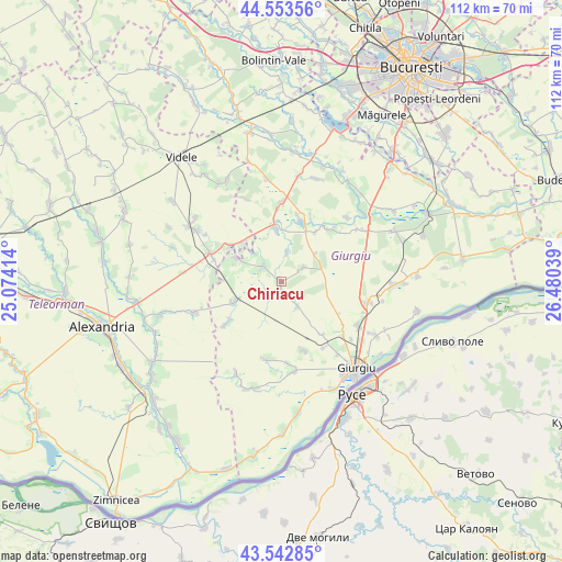
Chiriacu GPS coordinates[2]
44° 3' 1.296" North, 25° 46' 38.136" East
| Map corner | latitude | longitude |
|---|---|---|
| Upper-left | 44.55356°, | 25.07414° |
| Center: | 44.05036°, | 25.77726° |
| Lower-right: | 43.54285°, | 26.48039° |
| Map W x H: | 112.4×112.4 km | = 69.8×69.8mi |
| max Lat: | 48.23793° ⇑96.2% North |
| Chiriacu: | 44.05036° |
| min Lat: | ⇓3.8% South 43.65638° |
| min Long | Chiriacu | max Long |
| 20.31667° | 25.77726° | 29.65403° |
| W 58.7%⇐ | ⇒41.3% E |
Elevation
Elevation of Chiriacu is 85 m = 279 ft, and this is 169.9 m = 557 ft below average elevation for this country.
| Max E: |
1278 m = 4193 ft | 82.8% |
| Avg. | 254.9 m = 836 ft | |
| Chiriacu | 85 m = 279 ft | |
Min E: |
-2 m = -7 ft | 17.2% |
See also: Romania elevation on elevation.city.
Geographical zone
Chiriacu is located in North temperate zone (between Tropic of Cancer and the Arctic Circle). Distance of this Northern Tropic circle is 2292 km =1424.2 mi to South.| Distance of | km | miles | from Chiriacu |
|---|---|---|---|
| North Pole | 5109.1 | 3174.6 | to North |
| Arctic Circle | 2503.2 | 1555.4 | to North |
| Tropic Cancer | 2292 | 1424.2 | to South |
| Equator | 4897.9 | 3043.4 | to South |


Nearby cities:
15 places around Chiriacu: (largest is in red/bold)
• Bila
14.6 km =9.1 mi,  24°
24°
• Bujoreni
13.7 km =8.5 mi,  302°
302°
• Cucuruzu
4.9 km =3 mi,  312°
312°
• Cămineasca
13.8 km =8.6 mi,  13°
13°
• Izvoarele
1.8 km =1.1 mi,  186°
186°
• Naipu
11.4 km =7.1 mi,  353°
353°
• Oncești
13.3 km =8.3 mi,  141°
141°
• Prunaru
11.3 km =7 mi,  316°
316°
• Răsuceni
10.2 km =6.3 mi, 296°
• Schitu
11.1 km =6.9 mi,  25°
25°
• Stoeneşti
14.1 km =8.8 mi,  41°
41°
• Tomulești
13.8 km =8.6 mi,  233°
233°
• Toporu
10.9 km =6.8 mi,  246°
246°
• Valea Bujorului
5.4 km =3.4 mi,  56°
56°
• Vlașin
8.5 km =5.3 mi,  49°
49°
Sources, notices
• [Note1] Compared only with cities in Romania existing in our database
• [Src1] Map data: © OpenStreetMap contributors (CC-BY-SA)
• [Src2] Other city data from geonames.org with taken over terms of usage.
• [Src3] Geographical zone / Annual Mean Temperature by Robert A. Rohde @ Wikipedia
