Zvorsca geodata
Zvorsca (Dolj) is a populated place; located in Romania in Europe/Bucharest (GMT+3) time zone. With population of 721 people, there are 5456 cities with bigger population in this country. Compared to other cities in Romania, 97.1% of cities are located further ↑North; 66.3% of cities are located further →East and 71.9% of cities have higher elevation than Zvorsca. Note1


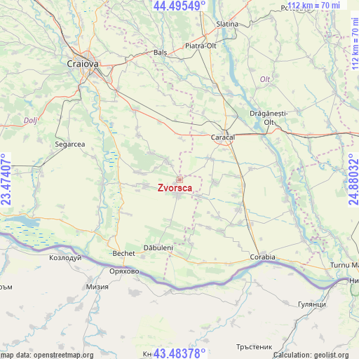
Zvorsca GPS coordinates[2]
43° 59' 30.444" North, 24° 10' 37.884" East
| Map corner | latitude | longitude |
|---|---|---|
| Upper-left | 44.49549°, | 23.47407° |
| Center: | 43.99179°, | 24.17719° |
| Lower-right: | 43.48378°, | 24.88032° |
| Map W x H: | 112.5×112.5 km | = 69.9×69.9mi |
| max Lat: | 48.23793° ⇑97.1% North |
| Zvorsca: | 43.99179° |
| min Lat: | ⇓2.9% South 43.65638° |
| min Long | Zvorsca | max Long |
| 20.31667° | 24.17719° | 29.65403° |
| W 33.7%⇐ | ⇒66.3% E |
Elevation
Elevation of Zvorsca is 120 m = 394 ft, and this is 134.9 m = 443 ft below average elevation for this country.
| Max E: |
1278 m = 4193 ft | 71.9% |
| Avg. | 254.9 m = 836 ft | |
| Zvorsca | 120 m = 394 ft | |
Min E: |
-2 m = -7 ft | 28.1% |
See also: Romania elevation on elevation.city.
Geographical zone
Zvorsca is located in North temperate zone (between Tropic of Cancer and the Arctic Circle). Distance of this Northern Tropic circle is 2285.5 km =1420.1 mi to South.| Distance of | km | miles | from Zvorsca |
|---|---|---|---|
| North Pole | 5115.6 | 3178.7 | to North |
| Arctic Circle | 2509.7 | 1559.5 | to North |
| Tropic Cancer | 2285.5 | 1420.1 | to South |
| Equator | 4891.4 | 3039.4 | to South |


Nearby cities:
15 places around Zvorsca: (largest is in red/bold)
• Amărăştii de Jos
4.7 km =2.9 mi,  190°
190°
• Amărăştii de Sus
2.4 km =1.5 mi,  246°
246°
• Bucinişu
7.5 km =4.7 mi,  128°
128°
• Bucinișu Mic
9 km =5.6 mi, 133°
• Celaru
7.4 km =4.6 mi,  331°
331°
• Dobrotești
5.4 km =3.4 mi,  231°
231°
• Dăneţi
10.2 km =6.3 mi,  264°
264°
• Ghizdăvești
9.2 km =5.7 mi,  322°
322°
• Marotinu de Jos
5 km =3.1 mi, 330°
• Marotinu de Sus
8.3 km =5.2 mi,  297°
297°
• Nisipuri
4.1 km =2.5 mi,  240°
240°
• Prapor
5.2 km =3.2 mi,  182°
182°
• Redea
11.8 km =7.3 mi,  56°
56°
• Rotunda
11.2 km =7 mi,  94°
94°
• Soreni
7.8 km =4.8 mi, 329°
Sources, notices
• [Note1] Compared only with cities in Romania existing in our database
• [Src1] Map data: © OpenStreetMap contributors (CC-BY-SA)
• [Src2] Other city data from geonames.org with taken over terms of usage.
• [Src3] Geographical zone / Annual Mean Temperature by Robert A. Rohde @ Wikipedia
