Bucinişu geodata
Bucinişu (Olt) is a seat of a second-order administrative division; located in Romania in Europe/Bucharest (GMT+3) time zone. With population of 2,306 people, there are 2318 cities with bigger population in this country. Compared to other cities in Romania, 97.7% of cities are located further ↑North; 65% of cities are located further →East and 74.2% of cities have higher elevation than Bucinişu. Note1


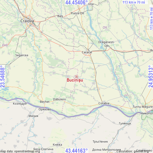
Bucinişu GPS coordinates[2]
43° 57' 0" North, 24° 15' 0" East
| Map corner | latitude | longitude |
|---|---|---|
| Upper-left | 44.45406°, | 23.54688° |
| Center: | 43.95°, | 24.25° |
| Lower-right: | 43.44163°, | 24.95313° |
| Map W x H: | 112.6×112.6 km | = 70×70mi |
| max Lat: | 48.23793° ⇑97.7% North |
| Bucinişu: | 43.95° |
| min Lat: | ⇓2.3% South 43.65638° |
| min Long | Bucinişu | max Long |
| 20.31667° | 24.25° | 29.65403° |
| W 35%⇐ | ⇒65% E |
Elevation
Elevation of Bucinişu is 113 m = 371 ft, and this is 141.9 m = 466 ft below average elevation for this country.
| Max E: |
1278 m = 4193 ft | 74.2% |
| Avg. | 254.9 m = 836 ft | |
| Bucinişu | 113 m = 371 ft | |
Min E: |
-2 m = -7 ft | 25.8% |
See also: Romania elevation on elevation.city.
Geographical zone
Bucinişu is located in North temperate zone (between Tropic of Cancer and the Arctic Circle). Distance of this Northern Tropic circle is 2280.9 km =1417.3 mi to South.| Distance of | km | miles | from Bucinişu |
|---|---|---|---|
| North Pole | 5120.3 | 3181.6 | to North |
| Arctic Circle | 2514.4 | 1562.4 | to North |
| Tropic Cancer | 2280.9 | 1417.3 | to South |
| Equator | 4886.8 | 3036.5 | to South |


Nearby cities:
15 places around Bucinişu: (largest is in red/bold)
• Amărăştii de Jos
6.7 km =4.2 mi,  270°
270°
• Amărăştii de Sus
8.8 km =5.5 mi,  294°
294°
• Arvăteasca
10.9 km =6.8 mi,  89°
89°
• Bucinișu Mic
1.7 km =1.1 mi,  156°
156°
• Câmpu Părului
6.5 km =4 mi,  148°
148°
• Dobrotești
10.2 km =6.3 mi,  277°
277°
• Grădinile
11.4 km =7.1 mi, 91°
• Nisipuri
9.8 km =6.1 mi, 285°
• Obârşia
10 km =6.2 mi,  138°
138°
• Prapor
6.1 km =3.8 mi,  264°
264°
• Redea
11.8 km =7.3 mi,  19°
19°
• Rotunda
6.5 km =4 mi,  55°
55°
• Stăvaru
9.5 km =5.9 mi,  175°
175°
• Urzica
10.8 km =6.7 mi, 163°
• Zvorsca
7.5 km =4.7 mi,  308°
308°
Sources, notices
• [Note1] Compared only with cities in Romania existing in our database
• [Src1] Map data: © OpenStreetMap contributors (CC-BY-SA)
• [Src2] Other city data from geonames.org with taken over terms of usage.
• [Src3] Geographical zone / Annual Mean Temperature by Robert A. Rohde @ Wikipedia
