Dobrotești geodata
Dobrotești (Dolj) is a seat of a second-order administrative division; located in Romania in Europe/Bucharest (GMT+3) time zone. With population of 1,392 people, there are 3350 cities with bigger population in this country. Compared to other cities in Romania, 97.5% of cities are located further ↑North; 67.4% of cities are located further →East and 71.6% of cities have higher elevation than Dobrotești. Note1


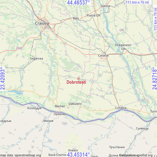
Dobrotești GPS coordinates[2]
43° 57' 41.076" North, 24° 7' 26.58" East
| Map corner | latitude | longitude |
|---|---|---|
| Upper-left | 44.46537°, | 23.42093° |
| Center: | 43.96141°, | 24.12405° |
| Lower-right: | 43.45314°, | 24.82718° |
| Map W x H: | 112.5×112.5 km | = 69.9×69.9mi |
| max Lat: | 48.23793° ⇑97.5% North |
| Dobrotești: | 43.96141° |
| min Lat: | ⇓2.5% South 43.65638° |
| min Long | Dobrotești | max Long |
| 20.31667° | 24.12405° | 29.65403° |
| W 32.6%⇐ | ⇒67.4% E |
Elevation
Elevation of Dobrotești is 121 m = 397 ft, and this is 133.9 m = 439 ft below average elevation for this country.
| Max E: |
1278 m = 4193 ft | 71.6% |
| Avg. | 254.9 m = 836 ft | |
| Dobrotești | 121 m = 397 ft | |
Min E: |
-2 m = -7 ft | 28.4% |
See also: Romania elevation on elevation.city.
Geographical zone
Dobrotești is located in North temperate zone (between Tropic of Cancer and the Arctic Circle). Distance of this Northern Tropic circle is 2282.1 km =1418 mi to South.| Distance of | km | miles | from Dobrotești |
|---|---|---|---|
| North Pole | 5119 | 3180.8 | to North |
| Arctic Circle | 2513.1 | 1561.6 | to North |
| Tropic Cancer | 2282.1 | 1418 | to South |
| Equator | 4888.1 | 3037.3 | to South |


Nearby cities:
15 places around Dobrotești: (largest is in red/bold)
• Amărăştii de Jos
3.6 km =2.2 mi,  110°
110°
• Amărăştii de Sus
3.2 km =2 mi,  40°
40°
• Brabeți
8.9 km =5.5 mi,  269°
269°
• Braniște
9.3 km =5.8 mi,  284°
284°
• Bucinişu
10.2 km =6.3 mi,  97°
97°
• Celaru
9.9 km =6.2 mi,  4°
4°
• Dăneţi
6.4 km =4 mi,  292°
292°
• Locusteni
10.2 km =6.3 mi, 278°
• Marotinu de Jos
8 km =5 mi,  13°
13°
• Marotinu de Sus
7.8 km =4.8 mi,  336°
336°
• Nisipuri
1.5 km =0.9 mi,  26°
26°
• Ocolna
9.2 km =5.7 mi,  174°
174°
• Prapor
4.5 km =2.8 mi, 114°
• Soreni
10.1 km =6.3 mi, 1°
• Zvorsca
5.4 km =3.4 mi,  51°
51°
Sources, notices
• [Note1] Compared only with cities in Romania existing in our database
• [Src1] Map data: © OpenStreetMap contributors (CC-BY-SA)
• [Src2] Other city data from geonames.org with taken over terms of usage.
• [Src3] Geographical zone / Annual Mean Temperature by Robert A. Rohde @ Wikipedia
