Soreni geodata
Soreni (Dolj) is a populated place; located in Romania in Europe/Bucharest (GMT+3) time zone. With population of 800 people, there are 5046 cities with bigger population in this country. Compared to other cities in Romania, 96.1% of cities are located further ↑North; 67.3% of cities are located further →East and 67.2% of cities have higher elevation than Soreni. Note1


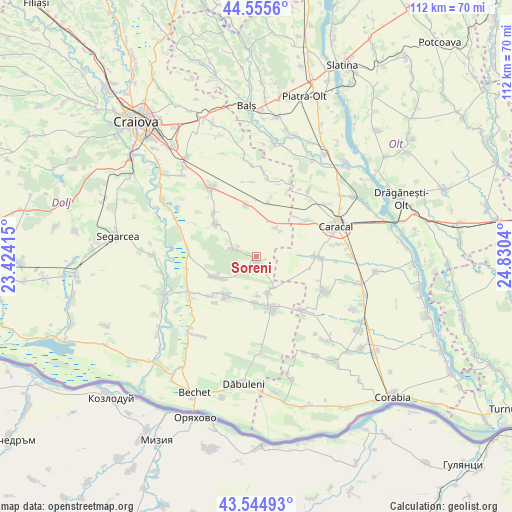
Soreni GPS coordinates[2]
44° 3' 8.712" North, 24° 7' 38.172" East
| Map corner | latitude | longitude |
|---|---|---|
| Upper-left | 44.5556°, | 23.42415° |
| Center: | 44.05242°, | 24.12727° |
| Lower-right: | 43.54493°, | 24.8304° |
| Map W x H: | 112.4×112.4 km | = 69.8×69.8mi |
| max Lat: | 48.23793° ⇑96.1% North |
| Soreni: | 44.05242° |
| min Lat: | ⇓3.9% South 43.65638° |
| min Long | Soreni | max Long |
| 20.31667° | 24.12727° | 29.65403° |
| W 32.7%⇐ | ⇒67.3% E |
Elevation
Elevation of Soreni is 138 m = 453 ft, and this is 116.9 m = 384 ft below average elevation for this country.
| Max E: |
1278 m = 4193 ft | 67.2% |
| Avg. | 254.9 m = 836 ft | |
| Soreni | 138 m = 453 ft | |
Min E: |
-2 m = -7 ft | 32.8% |
See also: Romania elevation on elevation.city.
Geographical zone
Soreni is located in North temperate zone (between Tropic of Cancer and the Arctic Circle). Distance of this Northern Tropic circle is 2292.3 km =1424.4 mi to South.| Distance of | km | miles | from Soreni |
|---|---|---|---|
| North Pole | 5108.9 | 3174.5 | to North |
| Arctic Circle | 2503 | 1555.3 | to North |
| Tropic Cancer | 2292.3 | 1424.4 | to South |
| Equator | 4898.2 | 3043.6 | to South |


Nearby cities:
15 places around Soreni: (largest is in red/bold)
• Amărăştii de Sus
7.9 km =4.9 mi,  166°
166°
• Apele Vii
5.1 km =3.2 mi,  288°
288°
• Castranova
11.4 km =7.1 mi,  308°
308°
• Celaru
0.6 km =0.4 mi,  119°
119°
• Dioşti
8.4 km =5.2 mi,  32°
32°
• Dobrotești
10.1 km =6.3 mi,  181°
181°
• Dăneţi
9.9 km =6.2 mi,  218°
218°
• Ghizdăvești
1.6 km =1 mi, 290°
• Marotinu de Jos
2.8 km =1.7 mi,  146°
146°
• Marotinu de Sus
4.5 km =2.8 mi,  229°
229°
• Mârşani
9.7 km =6 mi,  245°
245°
• Nisipuri
8.8 km =5.5 mi, 177°
• Radomir
8.3 km =5.2 mi,  23°
23°
• Zvorsca
7.8 km =4.8 mi, 149°
• Zănoaga
11.6 km =7.2 mi,  348°
348°
Sources, notices
• [Note1] Compared only with cities in Romania existing in our database
• [Src1] Map data: © OpenStreetMap contributors (CC-BY-SA)
• [Src2] Other city data from geonames.org with taken over terms of usage.
• [Src3] Geographical zone / Annual Mean Temperature by Robert A. Rohde @ Wikipedia
