Volovăţ geodata
Volovăţ (Suceava) is a seat of a second-order administrative division; located in Romania in Europe/Bucharest (GMT+3) time zone. With population of 6,990 people, there are 411 cities with bigger population in this country. Compared to other cities in Romania, 96.8% of cities are located further ↓South; 61% of cities are located further ←West and 78.9% of cities have lower elevation than Volovăţ. Note1


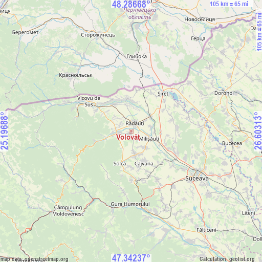
Volovăţ GPS coordinates[2]
47° 49' 0.012" North, 25° 54' 0" East
| Map corner | latitude | longitude |
|---|---|---|
| Upper-left | 48.28668°, | 25.19688° |
| Center: | 47.81667°, | 25.9° |
| Lower-right: | 47.34237°, | 26.60313° |
| Map W x H: | 105×105 km | = 65.2×65.2mi |
| max Lat: | 48.23793° ⇑3.2% North |
| Volovăţ: | 47.81667° |
| min Lat: | ⇓96.8% South 43.65638° |
| min Long | Volovăţ | max Long |
| 20.31667° | 25.9° | 29.65403° |
| W 61%⇐ | ⇒39% E |
Elevation
Elevation of Volovăţ is 383 m = 1257 ft, and this is 128.1 m = 420 ft above average elevation for this country.
| Max E: |
1278 m = 4193 ft | 21.1% |
| Volovăţ | 383 m 1257 ft | |
| Avg. | 254.9 m = 836 ft | |
Min E: |
-2 m = -7 ft | 78.9% |
See also: Romania elevation on elevation.city.
Geographical zone
Volovăţ is located in North temperate zone (between Tropic of Cancer and the Arctic Circle). Distance of this North polar circle is 2084.5 km =1295.2 mi to North.| Distance of | km | miles | from Volovăţ |
|---|---|---|---|
| North Pole | 4690.3 | 2914.4 | to North |
| Arctic Circle | 2084.5 | 1295.2 | to North |
| Tropic Cancer | 2710.8 | 1684.4 | to South |
| Equator | 5316.7 | 3303.6 | to South |


Nearby cities:
15 places around Volovăţ: (largest is in red/bold)
• Arbore
9.6 km =6 mi,  164°
164°
• Burla
3.6 km =2.2 mi,  145°
145°
• Bădeuți
6.5 km =4 mi,  103°
103°
• Clit
7.7 km =4.8 mi,  204°
204°
• Dorneşti
9.9 km =6.2 mi,  51°
51°
• Frătăuţii Vechi
9.3 km =5.8 mi,  352°
352°
• Horodnic de Jos
8.1 km =5 mi,  311°
311°
• Horodnic de Sus
6.3 km =3.9 mi,  294°
294°
• Iaslovăț
8.7 km =5.4 mi,  138°
138°
• Marginea
6.2 km =3.9 mi,  270°
270°
• Milişăuţi
8.3 km =5.2 mi,  116°
116°
• Rădăuți
3.9 km =2.4 mi,  18°
18°
• Satu Mare
8.9 km =5.5 mi,  77°
77°
• Voievodeasa
11.4 km =7.1 mi,  260°
260°
• Țibeni
9.3 km =5.8 mi,  90°
90°
Sources, notices
• [Note1] Compared only with cities in Romania existing in our database
• [Src1] Map data: © OpenStreetMap contributors (CC-BY-SA)
• [Src2] Other city data from geonames.org with taken over terms of usage.
• [Src3] Geographical zone / Annual Mean Temperature by Robert A. Rohde @ Wikipedia
