Burla geodata
Burla (Suceava) is a seat of a second-order administrative division; located in Romania in Europe/Bucharest (GMT+3) time zone. With population of 1,885 people, there are 2723 cities with bigger population in this country. Compared to other cities in Romania, 96.5% of cities are located further ↓South; 61.4% of cities are located further ←West and 83.4% of cities have lower elevation than Burla. Note1


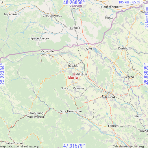
Burla GPS coordinates[2]
47° 47' 25.188" North, 25° 55' 37.056" East
| Map corner | latitude | longitude |
|---|---|---|
| Upper-left | 48.26058°, | 25.22384° |
| Center: | 47.79033°, | 25.92696° |
| Lower-right: | 47.31579°, | 26.63009° |
| Map W x H: | 105.1×10⁵ km | = 65.3×65.2mi |
| max Lat: | 48.23793° ⇑3.5% North |
| Burla: | 47.79033° |
| min Lat: | ⇓96.5% South 43.65638° |
| min Long | Burla | max Long |
| 20.31667° | 25.92696° | 29.65403° |
| W 61.4%⇐ | ⇒38.6% E |
Elevation
Elevation of Burla is 428 m = 1404 ft, and this is 173.1 m = 568 ft above average elevation for this country.
| Max E: |
1278 m = 4193 ft | 16.6% |
| Burla | 428 m 1404 ft | |
| Avg. | 254.9 m = 836 ft | |
Min E: |
-2 m = -7 ft | 83.4% |
See also: Romania elevation on elevation.city.
Geographical zone
Burla is located in North temperate zone (between Tropic of Cancer and the Arctic Circle). Distance of this North polar circle is 2087.4 km =1297 mi to North.| Distance of | km | miles | from Burla |
|---|---|---|---|
| North Pole | 4693.3 | 2916.3 | to North |
| Arctic Circle | 2087.4 | 1297 | to North |
| Tropic Cancer | 2707.9 | 1682.6 | to South |
| Equator | 5313.8 | 3301.8 | to South |


Nearby cities:
15 places around Burla: (largest is in red/bold)
• Arbore
6.4 km =4 mi,  175°
175°
• Bădeuți
4.5 km =2.8 mi,  71°
71°
• Cajvana
10.5 km =6.5 mi,  163°
163°
• Clit
6.6 km =4.1 mi,  232°
232°
• Dorneşti
10.7 km =6.6 mi,  32°
32°
• Gura Solcii
10.7 km =6.6 mi,  120°
120°
• Horodnic de Sus
9.5 km =5.9 mi,  305°
305°
• Iaslovăț
5.2 km =3.2 mi,  133°
133°
• Marginea
8.7 km =5.4 mi,  289°
289°
• Milişăuţi
5.5 km =3.4 mi,  98°
98°
• Rădăuți
6.7 km =4.2 mi,  353°
353°
• Satu Mare
8.2 km =5.1 mi,  54°
54°
• Slobozia Sucevei
9.4 km =5.8 mi,  107°
107°
• Volovăţ
3.6 km =2.2 mi,  325°
325°
• Țibeni
7.8 km =4.8 mi, 68°
Sources, notices
• [Note1] Compared only with cities in Romania existing in our database
• [Src1] Map data: © OpenStreetMap contributors (CC-BY-SA)
• [Src2] Other city data from geonames.org with taken over terms of usage.
• [Src3] Geographical zone / Annual Mean Temperature by Robert A. Rohde @ Wikipedia
