Iaslovăț geodata
Iaslovăț (Suceava) is a seat of a second-order administrative division; located in Romania in Europe/Bucharest (GMT+3) time zone. With population of 3,299 people, there are 1553 cities with bigger population in this country. Compared to other cities in Romania, 95.9% of cities are located further ↓South; 62.4% of cities are located further ←West and 76% of cities have lower elevation than Iaslovăț. Note1


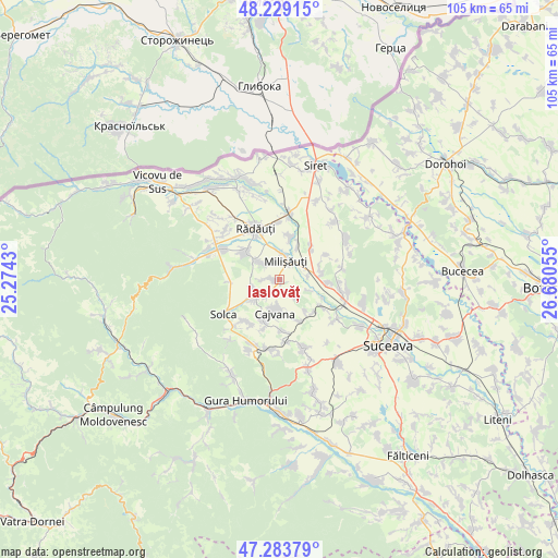
Iaslovăț GPS coordinates[2]
47° 45' 31.032" North, 25° 58' 38.712" East
| Map corner | latitude | longitude |
|---|---|---|
| Upper-left | 48.22915°, | 25.2743° |
| Center: | 47.75862°, | 25.97742° |
| Lower-right: | 47.28379°, | 26.68055° |
| Map W x H: | 105.1×105.1 km | = 65.3×65.3mi |
| max Lat: | 48.23793° ⇑4.1% North |
| Iaslovăț: | 47.75862° |
| min Lat: | ⇓95.9% South 43.65638° |
| min Long | Iaslovăț | max Long |
| 20.31667° | 25.97742° | 29.65403° |
| W 62.4%⇐ | ⇒37.6% E |
Elevation
Elevation of Iaslovăț is 361 m = 1184 ft, and this is 106.1 m = 348 ft above average elevation for this country.
| Max E: |
1278 m = 4193 ft | 24% |
| Iaslovăț | 361 m 1184 ft | |
| Avg. | 254.9 m = 836 ft | |
Min E: |
-2 m = -7 ft | 76% |
See also: Romania elevation on elevation.city.
Geographical zone
Iaslovăț is located in North temperate zone (between Tropic of Cancer and the Arctic Circle). Distance of this North polar circle is 2090.9 km =1299.2 mi to North.| Distance of | km | miles | from Iaslovăț |
|---|---|---|---|
| North Pole | 4696.8 | 2918.5 | to North |
| Arctic Circle | 2090.9 | 1299.2 | to North |
| Tropic Cancer | 2704.3 | 1680.4 | to South |
| Equator | 5310.3 | 3299.7 | to South |


Nearby cities:
15 places around Iaslovăț: (largest is in red/bold)
• Arbore
4.3 km =2.7 mi,  229°
229°
• Botoşana
8.6 km =5.3 mi,  193°
193°
• Burla
5.2 km =3.2 mi,  313°
313°
• Bădeuți
4.9 km =3 mi,  5°
5°
• Cajvana
6.6 km =4.1 mi, 187°
• Gura Solcii
5.8 km =3.6 mi,  109°
109°
• Iacobești
8.1 km =5 mi,  84°
84°
• Milişăuţi
3.2 km =2 mi,  31°
31°
• Românești
8.4 km =5.2 mi,  70°
70°
• Satu Mare
8.8 km =5.5 mi,  19°
19°
• Slobozia Sucevei
5.2 km =3.2 mi, 83°
• Soloneț
9 km =5.6 mi,  152°
152°
• Todireşti
7.7 km =4.8 mi, 147°
• Volovăţ
8.7 km =5.4 mi,  318°
318°
• Țibeni
7.3 km =4.5 mi, 28°
Sources, notices
• [Note1] Compared only with cities in Romania existing in our database
• [Src1] Map data: © OpenStreetMap contributors (CC-BY-SA)
• [Src2] Other city data from geonames.org with taken over terms of usage.
• [Src3] Geographical zone / Annual Mean Temperature by Robert A. Rohde @ Wikipedia
